IMAGES TAKEN NEAR TO
Bury Common, PULBOROUGH, RH20 1NP
Introduction
This page details the photographs taken nearby to Bury Common, RH20 1NP by members of the Geograph project.
The Geograph project started in 2005 with the aim of publishing, organising and preserving representative images for every square kilometre of Great Britain, Ireland and the Isle of Man.

There are currently over 7.5m images from over14,400 individuals and you can help contribute to the project by visiting https://www.geograph.org.uk
Image Map (Loading...)


Getting Data...Please wait
Leaflet Map data © OpenStreetMap
Images are licensed for reuse under creativecommons.org/licenses/by-sa/2.0
Notes
- Clicking on the map will re-center to the selected point.
- The higher the marker number, the further away the image location is from the centre of the postcode.
Image Listing (39 Images Found)
Images are licensed for reuse under creativecommons.org/licenses/by-sa/2.0
Image
Details
Distance
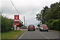
3
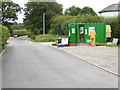
Site office for works off the A29 at Bury Hill
Image: © Shazz
Taken: 30 Jul 2015
0.03 miles
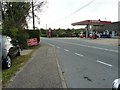
4
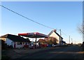
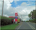
Turners Garage, Bury Common
The garage was established in the early 1920s and has a Murco filling station attached to its premises. Beyond are Wayside and Bury Common Cottage.
Image: © Simon Carey
Taken: 28 Dec 2017
0.04 miles
6
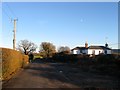
Croft Cottage, Bury Common
Built in the late 19th century next to the drive to Timberley Farm.
Image: © Simon Carey
Taken: 28 Dec 2017
0.04 miles
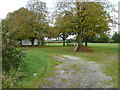
9
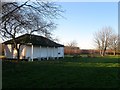
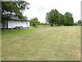
Pavilion, Recreation Ground, Bury Common
Home to Bury & West Burton Cricket Club, one of the oldest in the country having formed in the 1780s. See also Image
Image: © Simon Carey
Taken: 28 Dec 2017
0.04 miles
10
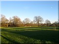
Recreation Ground, Bury Common
Used by Bury & West Burton Cricket Club which formed in the mid 1780s and is one of the oldest clubs in the country. When the common was enclosed sometime between 1813 and 1839 this part was set aside for the club's use and is actually marked as a recreation ground on Bury's 1839 tithe map.
Image: © Simon Carey
Taken: 28 Dec 2017
0.05 miles