IMAGES TAKEN NEAR TO
Colebrook Lane, PULBOROUGH, RH20 1NA
Introduction
This page details the photographs taken nearby to Colebrook Lane, RH20 1NA by members of the Geograph project.
The Geograph project started in 2005 with the aim of publishing, organising and preserving representative images for every square kilometre of Great Britain, Ireland and the Isle of Man.

There are currently over 7.5m images from over14,400 individuals and you can help contribute to the project by visiting https://www.geograph.org.uk
Image Map (Loading...)


Getting Data...Please wait
Leaflet Map data © OpenStreetMap
Images are licensed for reuse under creativecommons.org/licenses/by-sa/2.0
Notes
- Clicking on the map will re-center to the selected point.
- The higher the marker number, the further away the image location is from the centre of the postcode.
Image Listing (25 Images Found)
Images are licensed for reuse under creativecommons.org/licenses/by-sa/2.0
Image
Details
Distance
2
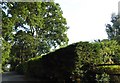
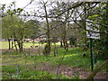
The end of Colebrook Lane, Watersfield
No vehicles beyond this point
Image: © David Howard
Taken: 18 Jul 2018
0.10 miles
4
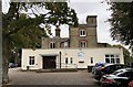
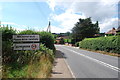
Lodge Hill
The Lodge Hill activity centre providing facilities for schools, groups and families.
Image: © Chris Thomas-Atkin
Taken: 4 Oct 2018
0.12 miles
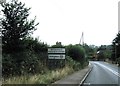
5
The camping site at Lodge Hill Centre
The picture was taken from Colebrook Lane.
Image: © Shazz
Taken: 3 Apr 2011
0.12 miles

9
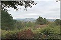
Trees at Lodge Hill
The grounds of the Lodge Hill activity centre are set in 32 acres of woodland. Beyond the trees there are far reaching views of the South Downs.
Image: © Chris Thomas-Atkin
Taken: 4 Oct 2018
0.14 miles
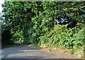
10

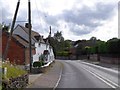
Colebrook Lane north of the houses
Colebrook Lane is mapped by OS as an "other route with public access".
Image: © Shazz
Taken: 3 Apr 2011
0.15 miles