IMAGES TAKEN NEAR TO
Woodruff Lane, PULBOROUGH, RH20 1JX
Introduction
This page details the photographs taken nearby to Woodruff Lane, RH20 1JX by members of the Geograph project.
The Geograph project started in 2005 with the aim of publishing, organising and preserving representative images for every square kilometre of Great Britain, Ireland and the Isle of Man.

There are currently over 7.5m images from over14,400 individuals and you can help contribute to the project by visiting https://www.geograph.org.uk
Image Map
Images are licensed for reuse under creativecommons.org/licenses/by-sa/2.0
Notes
- Clicking on the map will re-center to the selected point.
- The higher the marker number, the further away the image location is from the centre of the postcode.
Image Listing (19 Images Found)
Images are licensed for reuse under creativecommons.org/licenses/by-sa/2.0
Image
Details
Distance
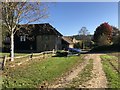
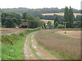
1
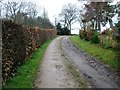
Track to Woodruff's Farm
Public footpath 3453.
Image: © Peter Holmes
Taken: 16 Apr 2016
0.04 miles
2
Stone Cottage
Viewed from the passing public footpath.
Image: © Chris Thomas-Atkin
Taken: 21 Oct 2018
0.07 miles
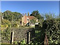
3
New Barn and Stone Cottage
Viewed from the footpath near High Hoes.
Image: © Robin Webster
Taken: 13 Feb 2007
0.08 miles
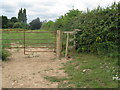
4
Footpath 670 east to New Barn
The footpath is the boundary between the two fields.
Image: © Dave Spicer
Taken: 31 Jul 2011
0.08 miles
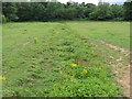
5
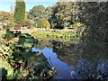
Small Pond
A small pond near Woodruff’s Farm.
Image: © Chris Thomas-Atkin
Taken: 21 Oct 2018
0.09 miles
7
Footpath from High Hoes to Woodruff's Farm
Image: © Dave Spicer
Taken: 7 Aug 2010
0.10 miles
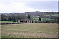
8
New Barn
The complex of buildings near Woodruff’s Farm.
Image: © Chris Thomas-Atkin
Taken: 21 Oct 2018
0.10 miles
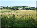
9
View west to New Barn near Woodruff's Farm
Hesworth Common is on the horizon
Image: © Dave Spicer
Taken: 22 Aug 2009
0.12 miles
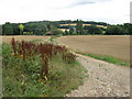
10
Field drainage channel running close to tributary of the River Rother
Birch Wood is at the end of the field.
Image: © Dave Spicer
Taken: 7 Aug 2010
0.12 miles