IMAGES TAKEN NEAR TO
Wyncombe Close, PULBOROUGH, RH20 1HW
Introduction
This page details the photographs taken nearby to Wyncombe Close, RH20 1HW by members of the Geograph project.
The Geograph project started in 2005 with the aim of publishing, organising and preserving representative images for every square kilometre of Great Britain, Ireland and the Isle of Man.

There are currently over 7.5m images from over14,400 individuals and you can help contribute to the project by visiting https://www.geograph.org.uk
Image Map (Loading...)


Getting Data...Please wait
Leaflet Map data © OpenStreetMap
Images are licensed for reuse under creativecommons.org/licenses/by-sa/2.0
Notes
- Clicking on the map will re-center to the selected point.
- The higher the marker number, the further away the image location is from the centre of the postcode.
Image Listing (48 Images Found)
Images are licensed for reuse under creativecommons.org/licenses/by-sa/2.0
Image
Details
Distance
1
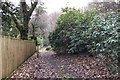
Rhododendrons on the common
Large rhododendrons alongside the path on the northern edge of Fittleworth Common.
Image: © Chris Thomas-Atkin
Taken: 5 Jan 2020
0.05 miles
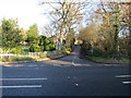
2
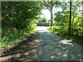
Limbourne Lane meets the A283 at Fittleworth
Limbourne Lane is a dead end road that finishes at Limbourne Farm.
Image: © Dave Spicer
Taken: 2 Jul 2011
0.05 miles
3
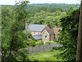
Houses on The Fleet, Fittleworth
Looking down from Fittleworth Common.
Image: © Robin Webster
Taken: 23 May 2011
0.05 miles
4
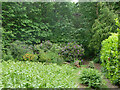
Footpath 685 and small clearing, Fittleworth Common
The small clearing is planted with some non-native species and appears to be an attempt to annex, or at least to divert to private purposes, some of the common land. Either bracken or some authority appears to have defeated this.
Image: © Robin Webster
Taken: 23 May 2011
0.06 miles
5
Road junction
Limbourne Lane meets the Fleet (A283)
Image: © The Saunterer
Taken: 8 Dec 2012
0.06 miles
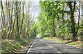
7
Footpath 685, Fittleworth
Heading west along the edge of Fittleworth Common, which is to the left.
Image: © Robin Webster
Taken: 23 May 2011
0.08 miles
8
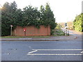
Post Box
RH20 106 The Fleet Fittleworth (Pulborough)
Image: © The Saunterer
Taken: 8 Dec 2012
0.09 miles
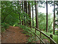
9
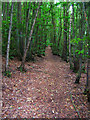
Footpath, Fittleworth Common
Open access land to the south east of the village between the A283 and Lea Farm Lane. This footpath links the A283 with School Lane in Fittleworth. The common itself occupies the slopes of Limburne Hill.
Image: © Simon Carey
Taken: 17 Aug 2007
0.10 miles
10

Limbourne Lane
Viewed north-east from the junction with the A283.
Image: © Frank Boait
Taken: 13 Jan 2010
0.11 miles