IMAGES TAKEN NEAR TO
Bury Gate, PULBOROUGH, RH20 1HA
Introduction
This page details the photographs taken nearby to Bury Gate, RH20 1HA by members of the Geograph project.
The Geograph project started in 2005 with the aim of publishing, organising and preserving representative images for every square kilometre of Great Britain, Ireland and the Isle of Man.

There are currently over 7.5m images from over14,400 individuals and you can help contribute to the project by visiting https://www.geograph.org.uk
Image Map
Images are licensed for reuse under creativecommons.org/licenses/by-sa/2.0
Notes
- Clicking on the map will re-center to the selected point.
- The higher the marker number, the further away the image location is from the centre of the postcode.
Image Listing (13 Images Found)
Images are licensed for reuse under creativecommons.org/licenses/by-sa/2.0
Image
Details
Distance

3
View across field next to the B2138
This was taken from the bridleway.
Image: © Shazz
Taken: 3 Apr 2011
0.13 miles
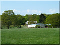
5
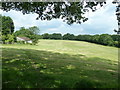
Recently cut pasture
Probably cut for silage.
Image: © Dave Spicer
Taken: 11 Jun 2011
0.15 miles
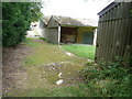
7
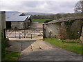
Farmyard on Stane Street
This was taken from the B2138.
Image: © Shazz
Taken: 3 Apr 2011
0.19 miles
8
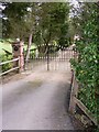
Gateway to Rats Castle
This is on the B2138 a quarter of a mile from the A29.
Image: © Shazz
Taken: 3 Apr 2011
0.19 miles
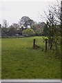
9
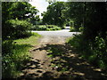
Road junction at the end of bridleway
The minor road opposite is Bignor Park Road.
Image: © Dave Spicer
Taken: 11 Jun 2011
0.20 miles
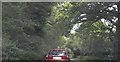
10
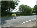
Bridleway junction on the B2138
The bridleway leads to Watersfield Common and just out of shot the minor road goes to Bignor Park.
Image: © Dave Spicer
Taken: 11 Jun 2011
0.21 miles