IMAGES TAKEN NEAR TO
Bury Gate, PULBOROUGH, RH20 1EZ
Introduction
This page details the photographs taken nearby to Bury Gate, RH20 1EZ by members of the Geograph project.
The Geograph project started in 2005 with the aim of publishing, organising and preserving representative images for every square kilometre of Great Britain, Ireland and the Isle of Man.

There are currently over 7.5m images from over14,400 individuals and you can help contribute to the project by visiting https://www.geograph.org.uk
Image Map
Images are licensed for reuse under creativecommons.org/licenses/by-sa/2.0
Notes
- Clicking on the map will re-center to the selected point.
- The higher the marker number, the further away the image location is from the centre of the postcode.
Image Listing (6 Images Found)
Images are licensed for reuse under creativecommons.org/licenses/by-sa/2.0
Image
Details
Distance
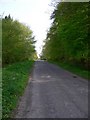
1
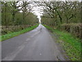
Road to Petworth
Dukes Copse on the left and Bowler's Copse on the right
Image: © Dave Spicer
Taken: 11 Apr 2009
0.21 miles
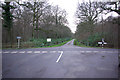
2
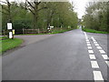
Road junction and entrance to Bignor Park
Image: © Dave Spicer
Taken: 11 Apr 2009
0.22 miles
3
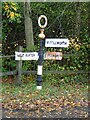
Direction Sign ? Signpost
Located on the west side of the T junction at the entrance to Bignor Park in Bury parish. 3 arms and annulus finial. See also https://www.geograph.org.uk/photo/1248290.
Milestone Society National ID: SX_SU9915
Image: © J Blemings
Taken: 26 Oct 2020
0.22 miles
4
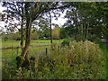
Trees by a ditch
I stopped to photograph the French-style plantation of young poplars (seen left) and only then realised that the rank vegetation in the foreground was growing along a roadside ditch - overgrown but still very wet.
Image: © Stefan Czapski
Taken: 9 Oct 2015
0.23 miles
5
The road by Bowler's Crab Wood looking south
The sign at the road junction with Bignor Park Road can be seen ahead.
Image: © Shazz
Taken: 17 Apr 2011
0.23 miles
6
Entrance Drive, Bignor Park
Viewed from the junction of Bignor Park Road (the viewpoint) and the West Burton - Petworth road. The sign to the left indicates Roman Villa (at Bignor).
Image: © Robin Webster
Taken: 12 Feb 2007
0.24 miles