IMAGES TAKEN NEAR TO
Coates Castle, PULBOROUGH, RH20 1EU
Introduction
This page details the photographs taken nearby to Coates Castle, RH20 1EU by members of the Geograph project.
The Geograph project started in 2005 with the aim of publishing, organising and preserving representative images for every square kilometre of Great Britain, Ireland and the Isle of Man.

There are currently over 7.5m images from over14,400 individuals and you can help contribute to the project by visiting https://www.geograph.org.uk
Image Map
Images are licensed for reuse under creativecommons.org/licenses/by-sa/2.0
Notes
- Clicking on the map will re-center to the selected point.
- The higher the marker number, the further away the image location is from the centre of the postcode.
Image Listing (8 Images Found)
Images are licensed for reuse under creativecommons.org/licenses/by-sa/2.0
Image
Details
Distance
2
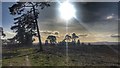
Lord's Piece, West Sussex
This part of the South Downs National Park has a relatively 'wild' and uncultivated feel to it.
Image: © Ian Hawfinch
Taken: 29 Jan 2020
0.16 miles
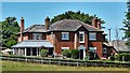
3
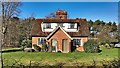
House on the north side of Lord's Piece, Sussex
Image: © Ian Hawfinch
Taken: 8 Feb 2020
0.16 miles
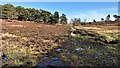
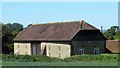
5
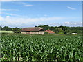
Converted barn at a place marked on the map as a Pumping House
Image: © Dave Spicer
Taken: 27 Jun 2009
0.18 miles
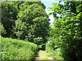
8
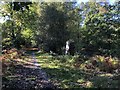
Passing through woodland at Lord?s Piece
The Serpent Trail as it crosses Lord’s Piece.
Image: © Chris Thomas-Atkin
Taken: 21 Oct 2018
0.25 miles