IMAGES TAKEN NEAR TO
Tripp Hill, PULBOROUGH, RH20 1ER
Introduction
This page details the photographs taken nearby to Tripp Hill, RH20 1ER by members of the Geograph project.
The Geograph project started in 2005 with the aim of publishing, organising and preserving representative images for every square kilometre of Great Britain, Ireland and the Isle of Man.

There are currently over 7.5m images from over14,400 individuals and you can help contribute to the project by visiting https://www.geograph.org.uk
Image Map (Loading...)


Getting Data...Please wait
Leaflet Map data © OpenStreetMap
Images are licensed for reuse under creativecommons.org/licenses/by-sa/2.0
Notes
- Clicking on the map will re-center to the selected point.
- The higher the marker number, the further away the image location is from the centre of the postcode.
Image Listing (31 Images Found)
Images are licensed for reuse under creativecommons.org/licenses/by-sa/2.0
Image
Details
Distance
1
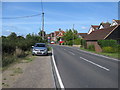
The B2138 at Lower Horncroft
The disused petrol station is now a car sales premises
Image: © Dave Spicer
Taken: 22 Aug 2009
0.01 miles
2
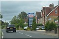
Proteus filling station, Lower Horncroft
Image: © N Chadwick
Taken: 24 Jun 2017
0.04 miles
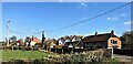
4
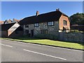
Cottages at Lower Horncroft
Cottages beside the B2138.
Image: © Chris Thomas-Atkin
Taken: 21 Oct 2018
0.07 miles
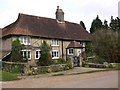
5
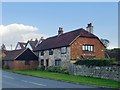
Cottages at Tripp Hill, Lower Horncroft
Image: © Stefan Czapski
Taken: 9 Oct 2015
0.08 miles
6
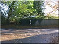
Road Junction
Coates Lane and B2138 on Tripp Hill
Image: © The Saunterer
Taken: 3 Nov 2012
0.09 miles
7
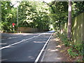
Junction of Coates Lane with the B 2138
Image: © Dave Spicer
Taken: 22 Aug 2009
0.10 miles
8
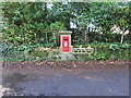
Georgian Post Box
RH20 54 Tripp Hill Manufacturer W.T. Allen & Co.
Image: © The Saunterer
Taken: 3 Nov 2012
0.10 miles
9
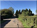
Approaching Tripp Hill Farm
On the Serpent Trail heading towards Tripp Hill Farm.
Image: © Chris Thomas-Atkin
Taken: 21 Oct 2018
0.11 miles