IMAGES TAKEN NEAR TO
Blackgate Lane, PULBOROUGH, RH20 1DF
Introduction
This page details the photographs taken nearby to Blackgate Lane, RH20 1DF by members of the Geograph project.
The Geograph project started in 2005 with the aim of publishing, organising and preserving representative images for every square kilometre of Great Britain, Ireland and the Isle of Man.

There are currently over 7.5m images from over14,400 individuals and you can help contribute to the project by visiting https://www.geograph.org.uk
Image Map (Loading...)


Getting Data...Please wait
Leaflet Map data © OpenStreetMap
Images are licensed for reuse under creativecommons.org/licenses/by-sa/2.0
Notes
- Clicking on the map will re-center to the selected point.
- The higher the marker number, the further away the image location is from the centre of the postcode.
Image Listing (17 Images Found)
Images are licensed for reuse under creativecommons.org/licenses/by-sa/2.0
Image
Details
Distance
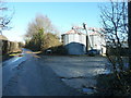
2
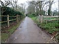
Driveway to Lee Place House and Farm
Beware of speed humps.
Image: © Peter Holmes
Taken: 15 Mar 2019
0.02 miles
3
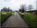
Why did the sheep cross the road ?
Public bridleway 774 to Lee Place Cottage.
Image: © Peter Holmes
Taken: 15 Mar 2019
0.03 miles
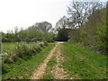
5
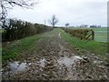
Muddy track to Tanners Farm
Public bridleway 780.
Image: © Peter Holmes
Taken: 15 Mar 2019
0.05 miles
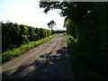
6

Track to North Wood
Public bridleway 1301.
Image: © Peter Holmes
Taken: 15 Mar 2019
0.06 miles
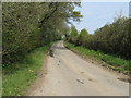
7
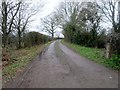
Track to Haybarn
Public bridleway 773 leaving Black Gate Lane.
Image: © Peter Holmes
Taken: 15 Mar 2019
0.10 miles
10
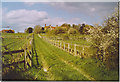
Lee Place House.
A wide grassy trackway is bordered by paddocks lined with wooden fencing. The local industry is now very much "horsieculture".
Image: © Colin Smith
Taken: 1 May 2006
0.16 miles