IMAGES TAKEN NEAR TO
Pickhurst Lane, PULBOROUGH, RH20 1DA
Introduction
This page details the photographs taken nearby to Pickhurst Lane, RH20 1DA by members of the Geograph project.
The Geograph project started in 2005 with the aim of publishing, organising and preserving representative images for every square kilometre of Great Britain, Ireland and the Isle of Man.

There are currently over 7.5m images from over14,400 individuals and you can help contribute to the project by visiting https://www.geograph.org.uk
Image Map
Images are licensed for reuse under creativecommons.org/licenses/by-sa/2.0
Notes
- Clicking on the map will re-center to the selected point.
- The higher the marker number, the further away the image location is from the centre of the postcode.
Image Listing (9 Images Found)
Images are licensed for reuse under creativecommons.org/licenses/by-sa/2.0
Image
Details
Distance
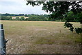
1
Fenced area at Tullen's Fruit Farm
Looks similar to a vineyard but could be raspberries.
Image: © Dave Spicer
Taken: 9 Jan 2011
0.05 miles
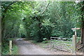
2
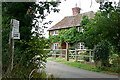
Entrance to Tullen's Farm
Right across the grid line, which goes up the track to Tullen's Farm. This must be an estate cottage.
Image: © Graham Horn
Taken: 4 Aug 2010
0.06 miles
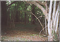
3

Woodbank by Pickhurst Lane
The trees to the left of the roadway are growing on what looks like a medieval woodbank. True, there is also a bank to the right of the lane, but seen 'on the ground' it is a less well defined feature, and doesn't show the characteristic profile (i.e. cross section).
The woodland here has plainly been managed as coppice in the past, though not systematically in more recent times.
Image: © Stefan Czapski
Taken: 29 Sep 2012
0.09 miles
4
In The Green Wood, near Codmore Hill.
Deciduous woodland in the Weald, good for grey squirrels!
Image: © Colin Smith
Taken: 4 Jun 2006
0.09 miles
6
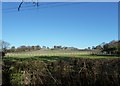
Farmland at Codmore Hill
The houses of the village can just be seen on the hill on the far side of the valley, carrying a tributary of the River Arun.
Image: © Graham Horn
Taken: 4 Aug 2010
0.14 miles
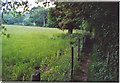
7
Footpath at Codmore Hill
Despite the many horse establishments in the area, and that this looks like a bridleway, it is just a footpath as the signs all confirm.
Image: © Graham Horn
Taken: 4 Aug 2010
0.15 miles
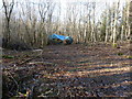
8
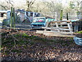
Abandoned Mini on the edge of Toat Plantation
Image: © Dave Spicer
Taken: 9 Jan 2011
0.15 miles
9
Footpath by Underley Copse, Pickhurst.
Typical Wealden scenery of fields and woods. In the distance, in front of the dark trunked tree, is a red deer.
Image: © Colin Smith
Taken: 4 Jun 2006
0.23 miles