IMAGES TAKEN NEAR TO
The Green, Stane Street Close, PULBOROUGH, RH20 1BE
Introduction
This page details the photographs taken nearby to The Green, Stane Street Close, RH20 1BE by members of the Geograph project.
The Geograph project started in 2005 with the aim of publishing, organising and preserving representative images for every square kilometre of Great Britain, Ireland and the Isle of Man.

There are currently over 7.5m images from over14,400 individuals and you can help contribute to the project by visiting https://www.geograph.org.uk
Image Map (Loading...)


Getting Data...Please wait
Leaflet Map data © OpenStreetMap
Images are licensed for reuse under creativecommons.org/licenses/by-sa/2.0
Notes
- Clicking on the map will re-center to the selected point.
- The higher the marker number, the further away the image location is from the centre of the postcode.
Image Listing (19 Images Found)
Images are licensed for reuse under creativecommons.org/licenses/by-sa/2.0
Image
Details
Distance
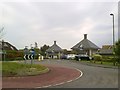
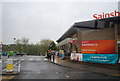
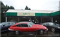
2
Roundabout on the A29 approaching Pulborough
Image: © David Howard
Taken: 15 Apr 2013
0.06 miles
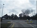
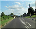
4
A29 midway between Pulborough and Codmore Hill
Image: © Dave Spicer
Taken: 11 Jun 2011
0.09 miles
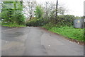
6
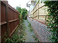
Footpath alongside new housing estate
On the outskirts of Pulborough.
Image: © Dave Spicer
Taken: 11 Jun 2011
0.13 miles
8
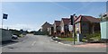
New housing estate being built, north of Pulborough
Image: © David Smith
Taken: 8 Jul 2019
0.17 miles
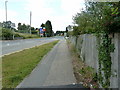
10
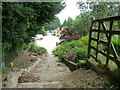
Footpath steps climbing away from the A29
Image: © Dave Spicer
Taken: 11 Jun 2011
0.20 miles