IMAGES TAKEN NEAR TO
Richmond Way, EAST GRINSTEAD, RH19 4TG
Introduction
This page details the photographs taken nearby to Richmond Way, RH19 4TG by members of the Geograph project.
The Geograph project started in 2005 with the aim of publishing, organising and preserving representative images for every square kilometre of Great Britain, Ireland and the Isle of Man.

There are currently over 7.5m images from over14,400 individuals and you can help contribute to the project by visiting https://www.geograph.org.uk
Image Map
Images are licensed for reuse under creativecommons.org/licenses/by-sa/2.0
Notes
- Clicking on the map will re-center to the selected point.
- The higher the marker number, the further away the image location is from the centre of the postcode.
Image Listing (447 Images Found)
Images are licensed for reuse under creativecommons.org/licenses/by-sa/2.0
Image
Details
Distance
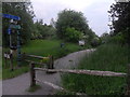
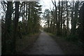
6
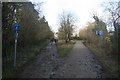
Approaching the end of the Forest Way
The Forest Way is situated in the heart of the beautiful East Sussex countryside. It is approximately 10 miles long and is used for walking, cycling, horse riding and the quiet enjoyment of the countryside. It runs from East Grinstead to Groombridge.
The Forest Way runs along an old railway line and is an important habitat for wildlife as a ‘green corridor'.
The way lies within the Forest Way Country Park. The Park lies within the High Weald Area of Outstanding Natural Beauty and passes through or close to East Grinstead, Forest Row, Hartfield, Withyham and Groombridge. There are circular trails varying in length and difficulty. Walkers may spot swallows, badger tracks deer and foxes, amongst the fields and woodlands.
The way follows the line of the old East Grinstead to Groombridge railway. The railway opened in 1866. Although a busy commuter line, it was axed with the Beeching cuts in 1966. Ironically, Dr Beeching lived near Forest Row and regularly travelled up to London on the line when he was Chairman of British Rail.
East Sussex County Council bought the line in 1971 and it was designated as a Country Park in 1974. In 2002, following improvements to the surfaced track Forest Way became part of the National Cycle Network.
The Park is owned by East Sussex County Council and managed by its Countryside Management Service.
Image: © N Chadwick
Taken: 6 Feb 2010
0.13 miles
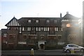
8
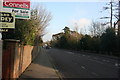
Hermitage Lane
Residential area on the southern side of East Grinstead.
Image: © Dave Spicer
Taken: 24 Oct 2012
0.13 miles
9
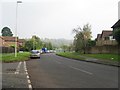
The Forest Way
The Forest Way is situated in the heart of the beautiful East Sussex countryside. It is approximately 10 miles long and is used for walking, cycling, horse riding and the quiet enjoyment of the countryside. It runs from East Grinstead to Groombridge.
The Forest Way runs along an old railway line and is an important habitat for wildlife as a ‘green corridor'.
The way lies within the Forest Way Country Park. The Park lies within the High Weald Area of Outstanding Natural Beauty and passes through or close to East Grinstead, Forest Row, Hartfield, Withyham and Groombridge. There are circular trails varying in length and difficulty. Walkers may spot swallows, badger tracks deer and foxes, amongst the fields and woodlands.
The way follows the line of the old East Grinstead to Groombridge railway. The railway opened in 1866. Although a busy commuter line, it was axed with the Beeching cuts in 1966. Ironically, Dr Beeching lived near Forest Row and regularly travelled up to London on the line when he was Chairman of British Rail.
East Sussex County Council bought the line in 1971 and it was designated as a Country Park in 1974. In 2002, following improvements to the surfaced track Forest Way became part of the National Cycle Network.
The Park is owned by East Sussex County Council and managed by its Countryside Management Service.
Image: © N Chadwick
Taken: 6 Feb 2010
0.14 miles
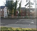
10
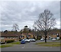
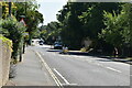
Windsor Close, East Grinstead
A cul de sac off Herontye Drive built in the late 1970s.
Image: © Simon Carey
Taken: 7 Apr 2021
0.14 miles