IMAGES TAKEN NEAR TO
Marlpit Road, EAST GRINSTEAD, RH19 4PD
Introduction
This page details the photographs taken nearby to Marlpit Road, RH19 4PD by members of the Geograph project.
The Geograph project started in 2005 with the aim of publishing, organising and preserving representative images for every square kilometre of Great Britain, Ireland and the Isle of Man.

There are currently over 7.5m images from over14,400 individuals and you can help contribute to the project by visiting https://www.geograph.org.uk
Image Map
Images are licensed for reuse under creativecommons.org/licenses/by-sa/2.0
Notes
- Clicking on the map will re-center to the selected point.
- The higher the marker number, the further away the image location is from the centre of the postcode.
Image Listing (99 Images Found)
Images are licensed for reuse under creativecommons.org/licenses/by-sa/2.0
Image
Details
Distance
1
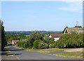
Marlpit Road, Sharpthorne
Residential road off station Road built in the late 1960s.
Image: © Simon Carey
Taken: 9 Aug 2020
0.02 miles
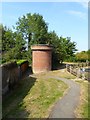
2
Air shaft for the Sharpthorne tunnel of the Bluebell Railway
Image: © Dave Spicer
Taken: 8 Aug 2009
0.04 miles

4
Air Shaft
For the Sharpthorne Tunnel on the Bluebell railway.
Image: © N Chadwick
Taken: 16 Jul 2013
0.06 miles
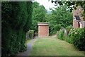
5
Air Shaft, Sharpthorne
One of two built for Sharpthorne Tunnel which runs under the village. Located at the entrance of Sharpthorne Play Area.
Image: © Simon Carey
Taken: 9 Aug 2020
0.06 miles
6
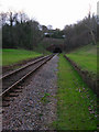
North Portal, Sharpthorne Tunnel
Closed in 1958 with the rest of the branch line and reopened in 1992 when the Bluebell Railway extended northwards to Kingscote. The platforms of the former West Hoathly station line the rail track.
Image: © Simon Carey
Taken: 1 Dec 2007
0.06 miles
7
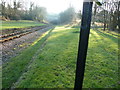
Looking south towards the northern portal of Sharpthorne tunnel
The only reason for including the black post was to prevent the glare of the low afternoon sun.
Image: © Dave Spicer
Taken: 11 Dec 2012
0.06 miles
8
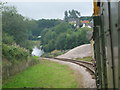
Steam exiting the tunnel
Steam escapes from the tunnel on the Bluebell railway. This was also the site of West Hoathley station which has been demolished.
Image: © Ashley Dace
Taken: 25 Aug 2008
0.06 miles

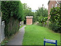
10
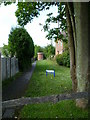
Play area in Sharpthorne
The brick tower is an air shaft for the Bluebell Railway Tunnel. An earlier view is at http://www.geograph.org.uk/photo/1435525.
Image: © Shazz
Taken: 13 Jun 2011
0.07 miles