IMAGES TAKEN NEAR TO
Medway Drive, EAST GRINSTEAD, RH19 4NB
Introduction
This page details the photographs taken nearby to Medway Drive, RH19 4NB by members of the Geograph project.
The Geograph project started in 2005 with the aim of publishing, organising and preserving representative images for every square kilometre of Great Britain, Ireland and the Isle of Man.

There are currently over 7.5m images from over14,400 individuals and you can help contribute to the project by visiting https://www.geograph.org.uk
Image Map
Images are licensed for reuse under creativecommons.org/licenses/by-sa/2.0
Notes
- Clicking on the map will re-center to the selected point.
- The higher the marker number, the further away the image location is from the centre of the postcode.
Image Listing (42 Images Found)
Images are licensed for reuse under creativecommons.org/licenses/by-sa/2.0
Image
Details
Distance
1
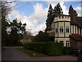
An Englishman's Home is His Castle
Castellated tower on a mock Tudor home in the southern marches of East Grinstead. This is an area of large detached houses.
Image: © Colin Smith
Taken: 5 Apr 2010
0.02 miles
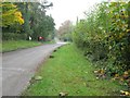
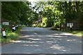
2
High Weald Landscape Trail
On the southern outskirts of East Grinstead.
Image: © Peter Trimming
Taken: 11 Aug 2023
0.03 miles
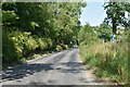
3
High Weald Landscape Trail on Coombehill Road East Grinstead
Image: © Dave Spicer
Taken: 24 Oct 2012
0.04 miles
5
On the High Weald Landscape Trail
The going gets muddy as the path is squeezed between hedgerows.
Image: © Colin Smith
Taken: 5 Apr 2010
0.07 miles
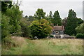
7
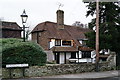
The Old Dunnings Mill
Located beside Dunnings Road, just south of East Grinstead.
Image: © Peter Trimming
Taken: 1 Jan 2019
0.11 miles
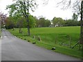
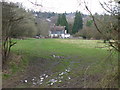
9
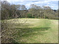
High Weald Landscape Trail
Crossing a grassy field on the edge of East Grinstead. The clay undersoil makes the going sticky after rain.
Image: © Colin Smith
Taken: 5 Apr 2010
0.12 miles
10
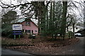
Peredur Centre for the Arts
Located on West Hoathley Road, south of East Grinstead. Peredur is the pink building to the left of picture. The cream building is Sunnyside Pre-School.
Image: © Peter Trimming
Taken: 1 Jan 2019
0.12 miles