IMAGES TAKEN NEAR TO
Coombe Hill Road, EAST GRINSTEAD, RH19 4LY
Introduction
This page details the photographs taken nearby to Coombe Hill Road, RH19 4LY by members of the Geograph project.
The Geograph project started in 2005 with the aim of publishing, organising and preserving representative images for every square kilometre of Great Britain, Ireland and the Isle of Man.

There are currently over 7.5m images from over14,400 individuals and you can help contribute to the project by visiting https://www.geograph.org.uk
Image Map
Images are licensed for reuse under creativecommons.org/licenses/by-sa/2.0
Notes
- Clicking on the map will re-center to the selected point.
- The higher the marker number, the further away the image location is from the centre of the postcode.
Image Listing (33 Images Found)
Images are licensed for reuse under creativecommons.org/licenses/by-sa/2.0
Image
Details
Distance
7
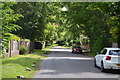
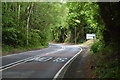
Saint Hill Road
Heading for Saint Hill Manor which is open to the public most of the year.
Image: © Dave Spicer
Taken: 24 Oct 2012
0.18 miles
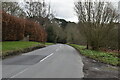
8
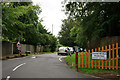
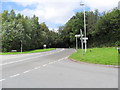
Coombe Hill Road
On the southern outskirts of East Grinstead, seen from Turner's Hill Road.
Image: © Peter Trimming
Taken: 29 Jun 2016
0.18 miles
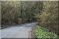
9
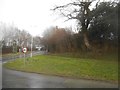
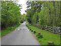
Saint Hill Road at the junction of Turners Hill Road
This was during a hailstorm
Image: © David Howard
Taken: 3 Apr 2016
0.18 miles