IMAGES TAKEN NEAR TO
Plawhatch Lane, EAST GRINSTEAD, RH19 4JL
Introduction
This page details the photographs taken nearby to Plawhatch Lane, RH19 4JL by members of the Geograph project.
The Geograph project started in 2005 with the aim of publishing, organising and preserving representative images for every square kilometre of Great Britain, Ireland and the Isle of Man.

There are currently over 7.5m images from over14,400 individuals and you can help contribute to the project by visiting https://www.geograph.org.uk
Image Map
Images are licensed for reuse under creativecommons.org/licenses/by-sa/2.0
Notes
- Clicking on the map will re-center to the selected point.
- The higher the marker number, the further away the image location is from the centre of the postcode.
Image Listing (23 Images Found)
Images are licensed for reuse under creativecommons.org/licenses/by-sa/2.0
Image
Details
Distance
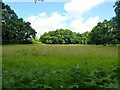
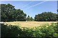
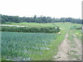
2
Twelve Acres
The name of the field according to East Grinstead's 1841 tithe map that is located to the south of Plawhatch Lane.
Image: © Simon Carey
Taken: 12 Jun 2022
0.07 miles
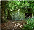
4
Site of Toll Wood
The name of the former wood according to East Grinstead's 1841 tithe map that once stood on the site bounded by the public footpath to the west and south and Plawhatch Lane to the north. This part was satill wooded according to the 1873 OS map but had gone by the 1899 edition.
Image: © Simon Carey
Taken: 12 Jun 2022
0.09 miles
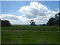
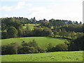
5
Field beside the Footpath
Looking across the field beside the public footpath towards the property noted on the OS Map as “Sherodin”.
Image: © Chris Thomas-Atkin
Taken: 1 Jul 2018
0.10 miles
6
Farm Shop, Plawhatch Farm
In operation for over thirty years and selling 90% of what the farm produces. Their speciality is raw milk.
Image: © Simon Carey
Taken: 12 Jun 2022
0.10 miles
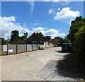
8
Forest Row 46b Public Footpath
The path links Cripps Manor in Ashdown Forest to Plawhatch Lane. The former barn on the right dates from the late 19th century.
Image: © Simon Carey
Taken: 12 Jun 2022
0.13 miles
9
Old Plawhatch Farm Shop
This is a 'bio dynamic' farm and a large variety of Organic produce is available all the year round, from sources very local or from far away
Image: © Nigel Freeman
Taken: 8 Jul 2005
0.13 miles
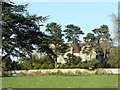
10
Plawhatch Hall from footpath above Plaw Wood
Image: © Dave Spicer
Taken: 24 Oct 2010
0.15 miles