IMAGES TAKEN NEAR TO
Chilling Street, EAST GRINSTEAD, RH19 4JF
Introduction
This page details the photographs taken nearby to Chilling Street, RH19 4JF by members of the Geograph project.
The Geograph project started in 2005 with the aim of publishing, organising and preserving representative images for every square kilometre of Great Britain, Ireland and the Isle of Man.

There are currently over 7.5m images from over14,400 individuals and you can help contribute to the project by visiting https://www.geograph.org.uk
Image Map
Images are licensed for reuse under creativecommons.org/licenses/by-sa/2.0
Notes
- Clicking on the map will re-center to the selected point.
- The higher the marker number, the further away the image location is from the centre of the postcode.
Image Listing (28 Images Found)
Images are licensed for reuse under creativecommons.org/licenses/by-sa/2.0
Image
Details
Distance
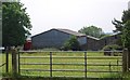
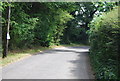
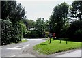
3
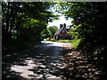
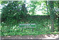
Tyes Cross
Road junction on the northern edge of Ashdown Forest
Image: © N Chadwick
Taken: 6 Jun 2006
0.08 miles
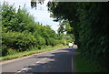
4
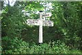
Old Direction Sign - Signpost by Top Road, Tyes Cross, West Hoathly Parish
Black iron cap finial - 3 arms; East Sussex wood by the UC road, in parish of West Hoathly (Mid Sussex District), Top Road junction with Chilling Street, on verge.
Surveyed
Milestone Society National ID: SX_TQ3832A
Image: © Milestone Society
Taken: Unknown
0.08 miles
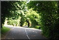
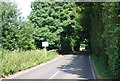
6
Chilling Street, Tye's Cross, West Sussex
Image: © nick macneill
Taken: 10 Aug 2012
0.08 miles