IMAGES TAKEN NEAR TO
Portland Road, EAST GRINSTEAD, RH19 4DZ
Introduction
This page details the photographs taken nearby to Portland Road, RH19 4DZ by members of the Geograph project.
The Geograph project started in 2005 with the aim of publishing, organising and preserving representative images for every square kilometre of Great Britain, Ireland and the Isle of Man.

There are currently over 7.5m images from over14,400 individuals and you can help contribute to the project by visiting https://www.geograph.org.uk
Image Map (Loading...)


Getting Data...Please wait
Leaflet Map data © OpenStreetMap
Images are licensed for reuse under creativecommons.org/licenses/by-sa/2.0
Notes
- Clicking on the map will re-center to the selected point.
- The higher the marker number, the further away the image location is from the centre of the postcode.
Image Listing (456 Images Found)
Images are licensed for reuse under creativecommons.org/licenses/by-sa/2.0
Image
Details
Distance
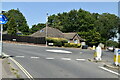
4
East Grinstead Tennis, Squash & Racketball Club
Image: © N Chadwick
Taken: 31 Jul 2020
0.10 miles
6
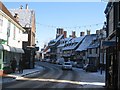
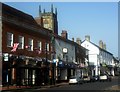
East Grinstead High Street
The row of Tudor houses on a snowy Sunday.
Image: © Ben Gamble
Taken: 20 Dec 2009
0.11 miles
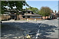
7

Clarendon Court
A block of four flats in Ship Street.
Image: © Russel Wills
Taken: 16 Nov 2011
0.14 miles
9
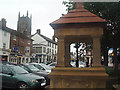
Water Fountain
Erected in 1887, to mark Queen Victoria’s Golden Jubilee, is now dry.
Image: © Nigel Freeman
Taken: 30 Sep 2005
0.15 miles
10
Looking along East Grinstead High Street - it seems there always has to be one ....
... Union flag amongst a row of them that ends up upside down.
Image: © Ed of the South
Taken: 28 Jun 2012
0.15 miles