IMAGES TAKEN NEAR TO
Dunnings Road, EAST GRINSTEAD, RH19 4AS
Introduction
This page details the photographs taken nearby to Dunnings Road, RH19 4AS by members of the Geograph project.
The Geograph project started in 2005 with the aim of publishing, organising and preserving representative images for every square kilometre of Great Britain, Ireland and the Isle of Man.

There are currently over 7.5m images from over14,400 individuals and you can help contribute to the project by visiting https://www.geograph.org.uk
Image Map
Images are licensed for reuse under creativecommons.org/licenses/by-sa/2.0
Notes
- Clicking on the map will re-center to the selected point.
- The higher the marker number, the further away the image location is from the centre of the postcode.
Image Listing (61 Images Found)
Images are licensed for reuse under creativecommons.org/licenses/by-sa/2.0
Image
Details
Distance
2
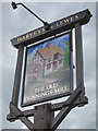
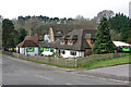
The Old Dunnings Mill sign
Sign for Image, a Harveys of Lewes pub on Dunnings Road.
Image: © Oast House Archive
Taken: 22 Jul 2011
0.02 miles
3
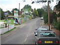
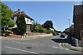
Dunnings Road
A new development of houses by Barratt Homes is underway on the left.
Image: © Oast House Archive
Taken: 22 Jul 2011
0.03 miles
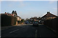
7
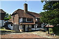
The Old Mill pub
Dunnings Lane, East Grinstead. Later called The Old Dunnings Mill.
Image: © Robin Webster
Taken: 11 Mar 2009
0.04 miles
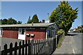
8
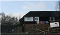
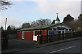
Guess what this is?
This is Dunnings Road Squash Club, East Grinstead
Image: © N Chadwick
Taken: 6 Feb 2010
0.04 miles