IMAGES TAKEN NEAR TO
Wray Close, EAST GRINSTEAD, RH19 3QX
Introduction
This page details the photographs taken nearby to Wray Close, RH19 3QX by members of the Geograph project.
The Geograph project started in 2005 with the aim of publishing, organising and preserving representative images for every square kilometre of Great Britain, Ireland and the Isle of Man.

There are currently over 7.5m images from over14,400 individuals and you can help contribute to the project by visiting https://www.geograph.org.uk
Image Map
Images are licensed for reuse under creativecommons.org/licenses/by-sa/2.0
Notes
- Clicking on the map will re-center to the selected point.
- The higher the marker number, the further away the image location is from the centre of the postcode.
Image Listing (47 Images Found)
Images are licensed for reuse under creativecommons.org/licenses/by-sa/2.0
Image
Details
Distance
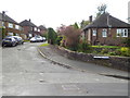
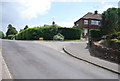
3
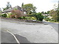
Junction of Woods Hill Lane and Woods Hill Close
See also http://www.geograph.org.uk/photo/1666698.
Image: © Shazz
Taken: 9 Oct 2016
0.07 miles
6
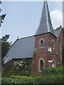
St Dunstan's Church at Ashurst Wood
A small place of worship in this pretty village.
Image: © Nigel Freeman
Taken: 24 Jun 2005
0.07 miles
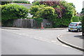
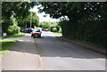
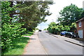
7

Woods Hill Lane
Woods Hill Close is at left.
Image: © Robin Webster
Taken: 17 Jan 2010
0.08 miles
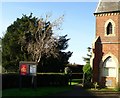
10
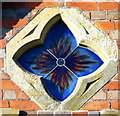
Quatrefoil window, St. Dunstan's, Ashurst Wood
Image: © nick macneill
Taken: 20 Dec 2013
0.10 miles