IMAGES TAKEN NEAR TO
Wilderwick Road, EAST GRINSTEAD, RH19 3NS
Introduction
This page details the photographs taken nearby to Wilderwick Road, RH19 3NS by members of the Geograph project.
The Geograph project started in 2005 with the aim of publishing, organising and preserving representative images for every square kilometre of Great Britain, Ireland and the Isle of Man.

There are currently over 7.5m images from over14,400 individuals and you can help contribute to the project by visiting https://www.geograph.org.uk
Image Map
Images are licensed for reuse under creativecommons.org/licenses/by-sa/2.0
Notes
- Clicking on the map will re-center to the selected point.
- The higher the marker number, the further away the image location is from the centre of the postcode.
Image Listing (16 Images Found)
Images are licensed for reuse under creativecommons.org/licenses/by-sa/2.0
Image
Details
Distance
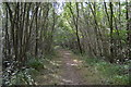
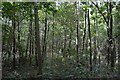
2
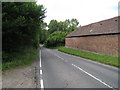
Wilderwick Road
Towards Dormansland. Wilderwick Farm to right.
Image: © Oast House Archive
Taken: 4 Jul 2010
0.05 miles
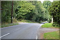
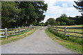
7
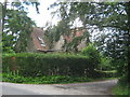
The Avenue Lodge
This lodge is on Wilderwick Road.
The Avenue (on the right) leads towards Walk Wood and Wilderwick House.
Image: © David Anstiss
Taken: 10 Jul 2011
0.13 miles