IMAGES TAKEN NEAR TO
Tower Court, Moat Road, EAST GRINSTEAD, RH19 3NL
Introduction
This page details the photographs taken nearby to Tower Court, Moat Road, RH19 3NL by members of the Geograph project.
The Geograph project started in 2005 with the aim of publishing, organising and preserving representative images for every square kilometre of Great Britain, Ireland and the Isle of Man.

There are currently over 7.5m images from over14,400 individuals and you can help contribute to the project by visiting https://www.geograph.org.uk
Image Map (Loading...)


Getting Data...Please wait
Leaflet Map data © OpenStreetMap
Images are licensed for reuse under creativecommons.org/licenses/by-sa/2.0
Notes
- Clicking on the map will re-center to the selected point.
- The higher the marker number, the further away the image location is from the centre of the postcode.
Image Listing (173 Images Found)
Images are licensed for reuse under creativecommons.org/licenses/by-sa/2.0
Image
Details
Distance
2
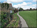
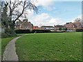
Path and cleaned ditch, King George's Field, East Grinstead
Image: © Robin Webster
Taken: 12 Mar 2022
0.04 miles
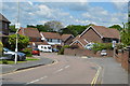
3
Pharmacy at Moatfield Surgery
View of Moatfield surgery from adjacent footpath.
Image: © Ed of the South
Taken: 20 Oct 2012
0.05 miles
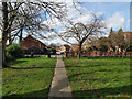
4
Path, King George's Field, East Grinstead
Image: © Robin Webster
Taken: 12 Mar 2022
0.06 miles
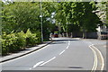
6
Way out to Moat Road, King George's Field, East Grinstead
Image: © Robin Webster
Taken: 12 Mar 2022
0.06 miles
8
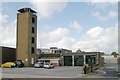
East Grinstead fire station
East Grinstead fire station, London Road, East Grinstead, West Sussex
Image: © Kevin Hale
Taken: 16 Jun 2007
0.07 miles
9
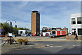
East Grinstead fire station
On London Road, A22.
Image: © Robin Webster
Taken: 7 Oct 2018
0.08 miles