IMAGES TAKEN NEAR TO
Greenhurst Drive, EAST GRINSTEAD, RH19 3NE
Introduction
This page details the photographs taken nearby to Greenhurst Drive, RH19 3NE by members of the Geograph project.
The Geograph project started in 2005 with the aim of publishing, organising and preserving representative images for every square kilometre of Great Britain, Ireland and the Isle of Man.

There are currently over 7.5m images from over14,400 individuals and you can help contribute to the project by visiting https://www.geograph.org.uk
Image Map
Images are licensed for reuse under creativecommons.org/licenses/by-sa/2.0
Notes
- Clicking on the map will re-center to the selected point.
- The higher the marker number, the further away the image location is from the centre of the postcode.
Image Listing (19 Images Found)
Images are licensed for reuse under creativecommons.org/licenses/by-sa/2.0
Image
Details
Distance
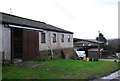
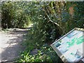
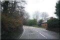
3
Lane to Fairlight Farm
Lane to Fairlight Farm off Holtye Road.
Image: © Ian Capper
Taken: 26 Sep 2023
0.14 miles
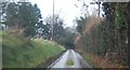
4
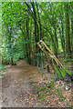
Path, Ashplats Wood
Path in Ashplats Wood.
Image: © Ian Capper
Taken: 26 Sep 2023
0.14 miles
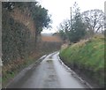
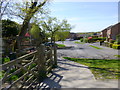
7
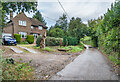
Fairlight Lodge
House near Fairlight Farm first marked on the 1931 25 inch map.
Image: © Ian Capper
Taken: 26 Sep 2023
0.16 miles
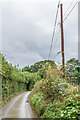
9
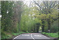
Looking west on Stirling Way from footpath junction
Image: © Shazz
Taken: 4 May 2016
0.18 miles