IMAGES TAKEN NEAR TO
Elizabeth Crescent, EAST GRINSTEAD, RH19 3JQ
Introduction
This page details the photographs taken nearby to Elizabeth Crescent, RH19 3JQ by members of the Geograph project.
The Geograph project started in 2005 with the aim of publishing, organising and preserving representative images for every square kilometre of Great Britain, Ireland and the Isle of Man.

There are currently over 7.5m images from over14,400 individuals and you can help contribute to the project by visiting https://www.geograph.org.uk
Image Map (Loading...)


Getting Data...Please wait
Leaflet Map data © OpenStreetMap
Images are licensed for reuse under creativecommons.org/licenses/by-sa/2.0
Notes
- Clicking on the map will re-center to the selected point.
- The higher the marker number, the further away the image location is from the centre of the postcode.
Image Listing (83 Images Found)
Images are licensed for reuse under creativecommons.org/licenses/by-sa/2.0
Image
Details
Distance
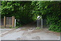
5
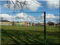
Through two fences, Blackwell Primary School
There is a chain link fence, not seen as the camera is sighted through the mesh, then this more recent fence stood off some way inboard. High security indeed!
Image: © Robin Webster
Taken: 12 Mar 2022
0.08 miles