IMAGES TAKEN NEAR TO
Rockdene Close, EAST GRINSTEAD, RH19 3HA
Introduction
This page details the photographs taken nearby to Rockdene Close, RH19 3HA by members of the Geograph project.
The Geograph project started in 2005 with the aim of publishing, organising and preserving representative images for every square kilometre of Great Britain, Ireland and the Isle of Man.

There are currently over 7.5m images from over14,400 individuals and you can help contribute to the project by visiting https://www.geograph.org.uk
Image Map
Images are licensed for reuse under creativecommons.org/licenses/by-sa/2.0
Notes
- Clicking on the map will re-center to the selected point.
- The higher the marker number, the further away the image location is from the centre of the postcode.
Image Listing (189 Images Found)
Images are licensed for reuse under creativecommons.org/licenses/by-sa/2.0
Image
Details
Distance
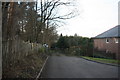
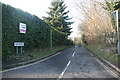
3
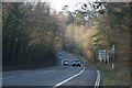
Beeching Way
This inner ring road follows the route of the old East Grinstead to Groombridge Railway. Closed in 1966, by Dr Beeching, who the road is named after.
Image: © N Chadwick
Taken: 6 Feb 2010
0.05 miles
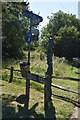
4
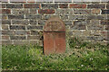
A millennium stone, Old Road, East Grinstead
One of several similar stones hereabouts, marking the Greenwich prime meridian.
Image: © Robin Webster
Taken: 2 May 2009
0.07 miles
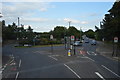
8
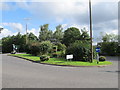
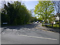
Roundabout, East Grinstead
The junction of Beeching Way (East Grinstead's town centre by-pass) and Lewes Road
Image: © Richard Rogerson
Taken: 21 Jul 2012
0.09 miles