IMAGES TAKEN NEAR TO
Sister Ann Way, EAST GRINSTEAD, RH19 3BQ
Introduction
This page details the photographs taken nearby to Sister Ann Way, RH19 3BQ by members of the Geograph project.
The Geograph project started in 2005 with the aim of publishing, organising and preserving representative images for every square kilometre of Great Britain, Ireland and the Isle of Man.

There are currently over 7.5m images from over14,400 individuals and you can help contribute to the project by visiting https://www.geograph.org.uk
Image Map
Images are licensed for reuse under creativecommons.org/licenses/by-sa/2.0
Notes
- Clicking on the map will re-center to the selected point.
- The higher the marker number, the further away the image location is from the centre of the postcode.
Image Listing (132 Images Found)
Images are licensed for reuse under creativecommons.org/licenses/by-sa/2.0
Image
Details
Distance
1
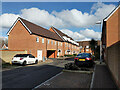
Houses, side road off Sister Ann Way, East Grinstead
The houses on the main road, side roads and paths are all numbered in the same Sister Ann Way sequence.
Image: © Robin Webster
Taken: 12 Mar 2022
0.01 miles
2
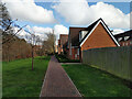
Path and houses off Sister Ann Way, East Grinstead
The houses on the main road, side roads and paths are all numbered in the same Sister Ann Way sequence.
Image: © Robin Webster
Taken: 12 Mar 2022
0.02 miles
3
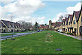
Houses on Sister Ann Way
A redevelopment of convent grounds.
Image: © Robin Webster
Taken: 12 Mar 2022
0.04 miles
4
Houses on Sister Ann Way
A redevelopment of convent grounds, the road is private but public footpath 55EG follows it at first.
Image: © Robin Webster
Taken: 12 Mar 2022
0.06 miles
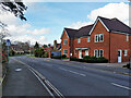
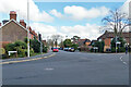
5
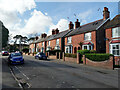
Houses, St John's Road, East Grinstead
Image: © Robin Webster
Taken: 12 Mar 2022
0.06 miles
6
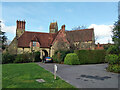
The Old Convent, East Grinstead
A residential conversion. Mostly hidden behind the gatehouse.
Image: © Robin Webster
Taken: 12 Mar 2022
0.07 miles
7
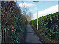
Footpath 1cEG, East Grinstead
North towards Hackenden Lane. Mount Noddy allotments are over the hedge on the right.
Image: © Robin Webster
Taken: 12 Mar 2022
0.07 miles
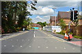
10
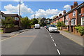
Road junction, East Grinstead
Looking from A264 Moat Road which turns sharply right, with Sister Ann Way left and St John's Road straight on.
Image: © Robin Webster
Taken: 12 Mar 2022
0.08 miles