IMAGES TAKEN NEAR TO
High Street, EAST GRINSTEAD, RH19 3AH
Introduction
This page details the photographs taken nearby to High Street, RH19 3AH by members of the Geograph project.
The Geograph project started in 2005 with the aim of publishing, organising and preserving representative images for every square kilometre of Great Britain, Ireland and the Isle of Man.

There are currently over 7.5m images from over14,400 individuals and you can help contribute to the project by visiting https://www.geograph.org.uk
Image Map
Images are licensed for reuse under creativecommons.org/licenses/by-sa/2.0
Notes
- Clicking on the map will re-center to the selected point.
- The higher the marker number, the further away the image location is from the centre of the postcode.
Image Listing (622 Images Found)
Images are licensed for reuse under creativecommons.org/licenses/by-sa/2.0
Image
Details
Distance
2
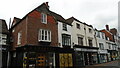
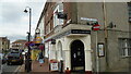
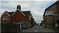
Premises on High Street, East Grinstead
The block is a grade II listed building, mid 19th century.
Image: © Robin Webster
Taken: 7 Oct 2018
0.01 miles
5
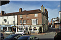
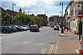
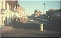
Rialto, East Grinstead
At the junction of the High Street with Cantelupe Road
Image: © Basher Eyre
Taken: 25 Aug 2021
0.01 miles
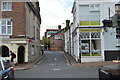
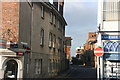
9
High Street (A22), East Grinstead in 1967
I took a similar view in 2011 http://www.geograph.org.uk/photo/2413410
Image: © John Baker
Taken: 4 Mar 1967
0.02 miles