IMAGES TAKEN NEAR TO
Copthorne Road, EAST GRINSTEAD, RH19 2QQ
Introduction
This page details the photographs taken nearby to Copthorne Road, RH19 2QQ by members of the Geograph project.
The Geograph project started in 2005 with the aim of publishing, organising and preserving representative images for every square kilometre of Great Britain, Ireland and the Isle of Man.

There are currently over 7.5m images from over14,400 individuals and you can help contribute to the project by visiting https://www.geograph.org.uk
Image Map
Images are licensed for reuse under creativecommons.org/licenses/by-sa/2.0
Notes
- Clicking on the map will re-center to the selected point.
- The higher the marker number, the further away the image location is from the centre of the postcode.
Image Listing (6 Images Found)
Images are licensed for reuse under creativecommons.org/licenses/by-sa/2.0
Image
Details
Distance
1
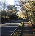
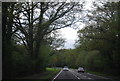
Copthorne Road
The Copthorne Road leaving Felbridge.
Image: © Chris Thomas-Atkin
Taken: 28 Dec 2017
0.10 miles
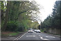
3
Path Junction
Path Junction on the Tandridge Border Path.
Image: © Chris Thomas-Atkin
Taken: 28 Dec 2017
0.13 miles
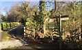
4
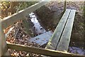
Two Footbridges
A curious arrangement of footbridges where the footpath crosses a small ditch. The wood footbridge appears to have replaced the previous way across over a slate slab.
Image: © Chris Thomas-Atkin
Taken: 28 Dec 2017
0.18 miles
6
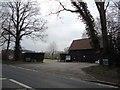
Entrance to Barong Conservatories, Felbridge
Image: © Stacey Harris
Taken: 29 Jan 2011
0.23 miles