IMAGES TAKEN NEAR TO
Glendale, EAST GRINSTEAD, RH19 2QN
Introduction
This page details the photographs taken nearby to Glendale, RH19 2QN by members of the Geograph project.
The Geograph project started in 2005 with the aim of publishing, organising and preserving representative images for every square kilometre of Great Britain, Ireland and the Isle of Man.

There are currently over 7.5m images from over14,400 individuals and you can help contribute to the project by visiting https://www.geograph.org.uk
Image Map
Images are licensed for reuse under creativecommons.org/licenses/by-sa/2.0
Notes
- Clicking on the map will re-center to the selected point.
- The higher the marker number, the further away the image location is from the centre of the postcode.
Image Listing (64 Images Found)
Images are licensed for reuse under creativecommons.org/licenses/by-sa/2.0
Image
Details
Distance
1
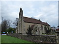
St John the Divine, Felbridge: mid December 2015
Image: © Basher Eyre
Taken: 19 Dec 2015
0.06 miles
2
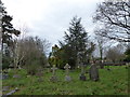
St John the Divine, Felbridge: churchyard (iv)
Image: © Basher Eyre
Taken: 19 Dec 2015
0.06 miles
3

St John the Divine, Felbridge: churchyard (v)
Image: © Basher Eyre
Taken: 19 Dec 2015
0.06 miles
4
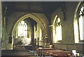
Interior of St John's church
St John's (built 1865) has a pleasant, light interior.
Image: © Stephen Craven
Taken: Unknown
0.06 miles
5
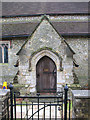
North porch of St John's church
This is the secondary entrance to the church. Planning permission was granted in 2010 for a project that would see the porch replaced by a new foyer / meeting room to provide better social facilities for the church.
See Image for context and Image for the main entrance.
Image: © Stephen Craven
Taken: 7 Feb 2011
0.06 miles
6
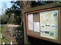
Felbridge Parish Council Noticeboard
Small pond just visible in the background
Image: © Barry Hunter
Taken: 20 Feb 2021
0.06 miles
7
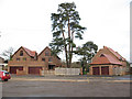
New houses on The Glebe
As the road name indicates, this was church land. These three houses were built c.2008 behind St John's church at Felbridge; the one on the right is the new vicarage and the others are private houses. The tall pine trees obviously predate the houses by many years.
Image: © Stephen Craven
Taken: 7 Feb 2011
0.06 miles
8
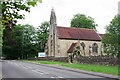
St John's Felbridge
The church of St John the Devine was built on the site of a chapel in 1865.
Image: © Glyn Baker
Taken: 28 Jun 2024
0.06 miles
9
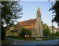
St John's, Felbridge
I was interested to notice that the prominent belfry at the west end doesn't qualify as either a tower or spire in traditional OS terms, and so the building is marked on the map by a simple cross.
In recent editions, of course, all places of worship are marked quite simply as 'PW', which seems to me a great shame, as the old symbols were always helpful in identifying distant landmarks.
Image: © Stefan Czapski
Taken: 20 Jun 2014
0.06 miles
10
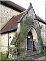
South porch of St John's church
This is the main entrance to the church of St John the Divine. See Image for context.
Image: © Stephen Craven
Taken: 7 Feb 2011
0.06 miles