IMAGES TAKEN NEAR TO
The Feld, London Road, EAST GRINSTEAD, RH19 2QL
Introduction
This page details the photographs taken nearby to The Feld, London Road, RH19 2QL by members of the Geograph project.
The Geograph project started in 2005 with the aim of publishing, organising and preserving representative images for every square kilometre of Great Britain, Ireland and the Isle of Man.

There are currently over 7.5m images from over14,400 individuals and you can help contribute to the project by visiting https://www.geograph.org.uk
Image Map
Images are licensed for reuse under creativecommons.org/licenses/by-sa/2.0
Notes
- Clicking on the map will re-center to the selected point.
- The higher the marker number, the further away the image location is from the centre of the postcode.
Image Listing (40 Images Found)
Images are licensed for reuse under creativecommons.org/licenses/by-sa/2.0
Image
Details
Distance
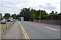
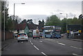
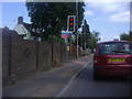
5
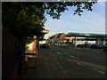
North End - London Road
View by the bus stop near the Felbridge hotel, looking down the A22 that eventually leads to the town centre.
Image: © Ed of the South
Taken: 3 Jun 2013
0.07 miles
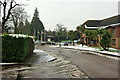
10
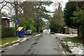
Furze Lane
This route, a public footpath, starts off as a presentable road, but later degenerates.
Image: © Robin Webster
Taken: 15 Jan 2010
0.10 miles