IMAGES TAKEN NEAR TO
Furzefield Chase, EAST GRINSTEAD, RH19 2LU
Introduction
This page details the photographs taken nearby to Furzefield Chase, RH19 2LU by members of the Geograph project.
The Geograph project started in 2005 with the aim of publishing, organising and preserving representative images for every square kilometre of Great Britain, Ireland and the Isle of Man.

There are currently over 7.5m images from over14,400 individuals and you can help contribute to the project by visiting https://www.geograph.org.uk
Image Map
Images are licensed for reuse under creativecommons.org/licenses/by-sa/2.0
Notes
- Clicking on the map will re-center to the selected point.
- The higher the marker number, the further away the image location is from the centre of the postcode.
Image Listing (49 Images Found)
Images are licensed for reuse under creativecommons.org/licenses/by-sa/2.0
Image
Details
Distance
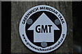
1
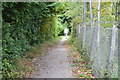
Tandridge Border Path & Greenwich Meridian Trail
Image: © N Chadwick
Taken: 31 Aug 2016
0.02 miles
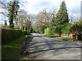
2
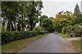
The Approach, Dormans Park
Road in the private estate of Dormans Park.
Image: © Ian Capper
Taken: 14 Oct 2016
0.03 miles

7
Furzefield Chase, Dormans Park
One of the main roads in the low density estate.
Image: © Robin Webster
Taken: 26 Feb 2020
0.04 miles
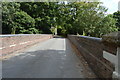
9
Railway bridge, The Approach
Bridge carrying the Approach over the East Grinstead railway.
Image: © Ian Capper
Taken: 14 Oct 2016
0.05 miles
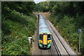
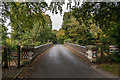
10
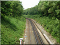
Railway looking north, Dormans Park
A view from the bridge carrying one of the principal roads in the estate - The Approach.
Image: © Robin Webster
Taken: 30 May 2011
0.05 miles