IMAGES TAKEN NEAR TO
Chestnut Walk, EAST GRINSTEAD, RH19 2LB
Introduction
This page details the photographs taken nearby to Chestnut Walk, RH19 2LB by members of the Geograph project.
The Geograph project started in 2005 with the aim of publishing, organising and preserving representative images for every square kilometre of Great Britain, Ireland and the Isle of Man.

There are currently over 7.5m images from over14,400 individuals and you can help contribute to the project by visiting https://www.geograph.org.uk
Image Map (35 Images)


Getting Data...Please wait
Leaflet Map data © OpenStreetMap
Images are licensed for reuse under creativecommons.org/licenses/by-sa/2.0
Notes
- Clicking on the map will re-center to the selected point.
- The higher the marker number, the further away the image location is from the centre of the postcode.
Image Listing (35 Images Found)
Images are licensed for reuse under creativecommons.org/licenses/by-sa/2.0
Image
Details
Distance

3
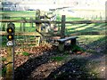
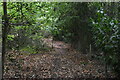
Tandridge Border Path
Branching point (situated in the Felcourt area) of the Tandridge Border Path; one heads north-easterly eventually joining with Blackberry Road, the other heads east towards Dormans Park.
Image: © Ed of the South
Taken: 12 Mar 2012
0.13 miles
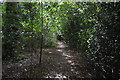
6
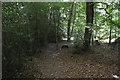
Public footpath near Felcourt
A public footpath through Surrey countryside, near the village of Felcourt.
Image: © Malc McDonald
Taken: 14 Dec 2019
0.14 miles
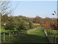
7
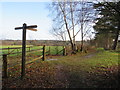
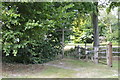
Public footpaths near Felcourt
A signpost at a junction of footpaths in the Surrey countryside, near Felcourt.
Image: © Malc McDonald
Taken: 14 Dec 2019
0.14 miles