IMAGES TAKEN NEAR TO
Alders View Drive, EAST GRINSTEAD, RH19 2DN
Introduction
This page details the photographs taken nearby to Alders View Drive, RH19 2DN by members of the Geograph project.
The Geograph project started in 2005 with the aim of publishing, organising and preserving representative images for every square kilometre of Great Britain, Ireland and the Isle of Man.

There are currently over 7.5m images from over14,400 individuals and you can help contribute to the project by visiting https://www.geograph.org.uk
Image Map (Loading...)


Getting Data...Please wait
Leaflet Map data © OpenStreetMap
Images are licensed for reuse under creativecommons.org/licenses/by-sa/2.0
Notes
- Clicking on the map will re-center to the selected point.
- The higher the marker number, the further away the image location is from the centre of the postcode.
Image Listing (37 Images Found)
Images are licensed for reuse under creativecommons.org/licenses/by-sa/2.0
Image
Details
Distance
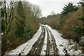
1
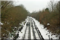
Railway towards East Grinstead
At this time this section has been closed for some days because of serious slipping of an embankment just south of Cook's Pond Viaduct. Work was in hand with some road-rail vehicles present, which may have used this stretch of line. The up track on the left looks quite rusty, but may have been used by a lightweight vehicle. However the right, down, track, the least affected by the slips, looks more used. That track is being use by aggregate trains supplying slip repairs. There seems no need for the topped and tailed trains to come this far south unless more than one such train is on the branch at once.
uth,
Image: © Robin Webster
Taken: 26 Feb 2020
0.06 miles
2
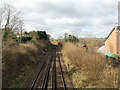
Railway to East Grinstead enters West Sussex
The bridge carrying footpath 416Sy is at the East Grinstead, Mid-Sussex District and county boundary.
Image: © Robin Webster
Taken: 15 Jan 2010
0.07 miles
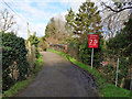
4
Footpath towards Blackwell Farm Road, East Grinstead
From Dormans Park.
Image: © Robin Webster
Taken: 25 Feb 2020
0.10 miles
5
Railway bridge HGG1 875
Hackenden Lane crosses the East Grinstead line.
Image: © Robin Webster
Taken: 26 Feb 2020
0.11 miles
6
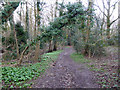
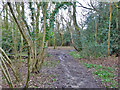
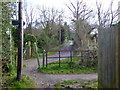
Footpath towards Dormans Park
Rather muddy, this is one of the better bits. There is an old pit or quarry on the left.
Image: © Robin Webster
Taken: 25 Feb 2020
0.14 miles
7
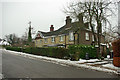
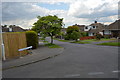
Hackenden House on Hackenden Lane
An older house in an area of more recent development.
Image: © Robin Webster
Taken: 15 Jan 2010
0.14 miles
8
Railway looking north into Surrey from West Sussex
The bridge carrying footpath 416Sy is just in West Sussex, the boundary being the north face of the bridge.
Image: © Robin Webster
Taken: 15 Jan 2010
0.14 miles