IMAGES TAKEN NEAR TO
Dorset Avenue, EAST GRINSTEAD, RH19 2AB
Introduction
This page details the photographs taken nearby to Dorset Avenue, RH19 2AB by members of the Geograph project.
The Geograph project started in 2005 with the aim of publishing, organising and preserving representative images for every square kilometre of Great Britain, Ireland and the Isle of Man.

There are currently over 7.5m images from over14,400 individuals and you can help contribute to the project by visiting https://www.geograph.org.uk
Image Map
Images are licensed for reuse under creativecommons.org/licenses/by-sa/2.0
Notes
- Clicking on the map will re-center to the selected point.
- The higher the marker number, the further away the image location is from the centre of the postcode.
Image Listing (44 Images Found)
Images are licensed for reuse under creativecommons.org/licenses/by-sa/2.0
Image
Details
Distance
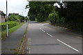
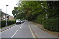
2
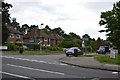
The A22, East Grinstead
It was a sunny day as you can see.
Image: © David Howard
Taken: 13 Jun 2011
0.12 miles
4
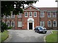
Imberhorne School
Imberhorne School, Windmill Lane http://www.imberhorne.w-sussex.sch.uk/
Image: © Nigel Freeman
Taken: 26 Aug 2006
0.12 miles