IMAGES TAKEN NEAR TO
London Road, EAST GRINSTEAD, RH19 1UA
Introduction
This page details the photographs taken nearby to London Road, RH19 1UA by members of the Geograph project.
The Geograph project started in 2005 with the aim of publishing, organising and preserving representative images for every square kilometre of Great Britain, Ireland and the Isle of Man.

There are currently over 7.5m images from over14,400 individuals and you can help contribute to the project by visiting https://www.geograph.org.uk
Image Map (262 Images)


Getting Data...Please wait
Leaflet Map data © OpenStreetMap
Images are licensed for reuse under creativecommons.org/licenses/by-sa/2.0
Notes
- Clicking on the map will re-center to the selected point.
- The higher the marker number, the further away the image location is from the centre of the postcode.
Image Listing (262 Images Found)
Images are licensed for reuse under creativecommons.org/licenses/by-sa/2.0
Image
Details
Distance
1
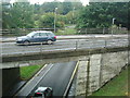
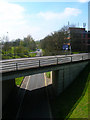
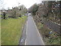
East Grinstead - road system
The lower road used to be the railway line - the upper road takes vehicles through the town.
Image: © Nigel Freeman
Taken: 30 Sep 2005
0.02 miles
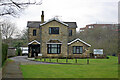
3
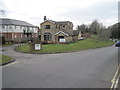
Old Station House, Beeching Way
The first station was built below the station house in the 1860s on the Three Bridges line which was later extended to Tunbridge Wells. When the Lewes-London line was constructed in 1882 a new station was built at the point where one crossed over the other. The old station house became an office in the Goods Yard and has survived the closures and landscaping of the former railway to become Beeching Way, the inner relief road. It is currently used as an office today.
Image: © Simon Carey
Taken: 20 Apr 2008
0.05 miles
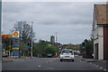
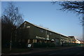
4
Kingdom Hall, East Grinstead
On the A22 London Road.
The taller building is St. James House used by the Open University.
Image: © David Anstiss
Taken: 16 May 2012
0.05 miles
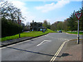
5
Beeching Way
The inner relief road for the town centre which follows the course of the former line to Tunbridge Wells. Viewed from the footbridge next to the London Road bridge.
Image: © Simon Carey
Taken: 20 Apr 2008
0.05 miles
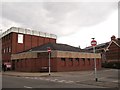
8
Former station house, East Grinstead
This was the location of the first station of 1855, at the terminus of the line from Three Bridges. East Grinstead has had a complicated railway history for a fairly small town. The passenger station moved to a new site on a new railway alignment in 1866 when the line was extended to Tunbridge Wells. In 1883 it moved again, with two levels, when the north-south route via Oxted to Lewes was progressively opened. Only the low level survives, with new buildings.
Image: © Robin Webster
Taken: 11 Mar 2009
0.06 miles
9
East Grinstead 2nd railway station (site), West Sussex
Opened in 1866 by the London Brighton and South Coast Railway on the line from Three Bridges to Tunbridge Wells, this station lasted until 1883 when it was replaced by a third station slightly further west and directly over the current railway station but at right angles to the platforms. View west towards Rowfant and Three Bridges, the trackbed now having been converted into a road
Image: © Nigel Thompson
Taken: 6 Apr 2013
0.06 miles
10
East Grinstead 1st railway station (site), West Sussex
Opened in 1855 as the terminus of a line from Three Bridges, on what became the London Brighton and South Coast Railway. The station was used by passengers only until 1866 when a second station was opened to the right of this image, on a line at a lower level (to fit under a bridge on London Road) when the line was extended to Tunbridge Wells. View west towards Rowfant and Three Bridges.
Image: © Nigel Thompson
Taken: 6 Apr 2013
0.06 miles