IMAGES TAKEN NEAR TO
Kingscote Way, EAST GRINSTEAD, RH19 1JH
Introduction
This page details the photographs taken nearby to Kingscote Way, RH19 1JH by members of the Geograph project.
The Geograph project started in 2005 with the aim of publishing, organising and preserving representative images for every square kilometre of Great Britain, Ireland and the Isle of Man.

There are currently over 7.5m images from over14,400 individuals and you can help contribute to the project by visiting https://www.geograph.org.uk
Image Map
Images are licensed for reuse under creativecommons.org/licenses/by-sa/2.0
Notes
- Clicking on the map will re-center to the selected point.
- The higher the marker number, the further away the image location is from the centre of the postcode.
Image Listing (13 Images Found)
Images are licensed for reuse under creativecommons.org/licenses/by-sa/2.0
Image
Details
Distance
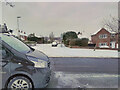
1
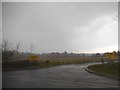
The entrance to Imberhorne Farm
This was in the middle of a major hailstorm with lightning. The haze you see is actually the hailstones.
Image: © David Howard
Taken: 3 Apr 2016
0.16 miles
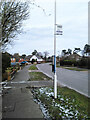
2
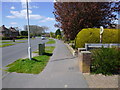
Looking west on Heathcote Drive with footpath junction on right
Image: © Shazz
Taken: 4 May 2016
0.18 miles