IMAGES TAKEN NEAR TO
Medway Drive, FOREST ROW, RH18 5NT
Introduction
This page details the photographs taken nearby to Medway Drive, RH18 5NT by members of the Geograph project.
The Geograph project started in 2005 with the aim of publishing, organising and preserving representative images for every square kilometre of Great Britain, Ireland and the Isle of Man.

There are currently over 7.5m images from over14,400 individuals and you can help contribute to the project by visiting https://www.geograph.org.uk
Image Map
Images are licensed for reuse under creativecommons.org/licenses/by-sa/2.0
Notes
- Clicking on the map will re-center to the selected point.
- The higher the marker number, the further away the image location is from the centre of the postcode.
Image Listing (47 Images Found)
Images are licensed for reuse under creativecommons.org/licenses/by-sa/2.0
Image
Details
Distance
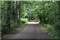
3
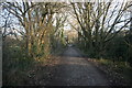
Forest Way
Railway built in 1866, closed in 1966.
Image: © N Chadwick
Taken: 1 Mar 2007
0.04 miles
4
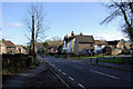
Hartfield Road at Post Horn Lane Junction
Looking towards Hartfield on B2110.
Image: © Robin Webster
Taken: 21 Jan 2007
0.05 miles
5
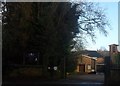
Our Lady of the Forest Catholic Church
Image: © Ed of the South
Taken: 13 Jan 2014
0.06 miles
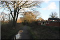
7
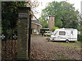
Caravan in the car park of Catholic church
Our Lady of the Forest church appears to have some repair work as scaffolding was being erected.
Image: © Dave Spicer
Taken: 24 Oct 2012
0.07 miles