IMAGES TAKEN NEAR TO
Tompsets Bank, FOREST ROW, RH18 5LW
Introduction
This page details the photographs taken nearby to Tompsets Bank, RH18 5LW by members of the Geograph project.
The Geograph project started in 2005 with the aim of publishing, organising and preserving representative images for every square kilometre of Great Britain, Ireland and the Isle of Man.

There are currently over 7.5m images from over14,400 individuals and you can help contribute to the project by visiting https://www.geograph.org.uk
Image Map
Images are licensed for reuse under creativecommons.org/licenses/by-sa/2.0
Notes
- Clicking on the map will re-center to the selected point.
- The higher the marker number, the further away the image location is from the centre of the postcode.
Image Listing (19 Images Found)
Images are licensed for reuse under creativecommons.org/licenses/by-sa/2.0
Image
Details
Distance
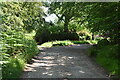
2
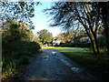
Public Byway on the SW corner of Forest Row
Image: © Dave Spicer
Taken: 11 Nov 2012
0.03 miles
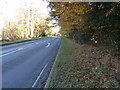
5
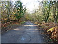
Byway 'Forest Row 59E' approaching the A22
Image: © Dave Spicer
Taken: 11 Nov 2012
0.11 miles
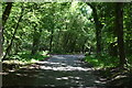
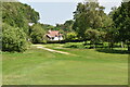
8
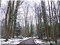
Drive through the woods to Ashdown Place
Just off the A22 south of Forest Row
Image: © Jonathan Billinger
Taken: 24 Jan 2007
0.17 miles