IMAGES TAKEN NEAR TO
London Road, FOREST ROW, RH18 5EJ
Introduction
This page details the photographs taken nearby to London Road, RH18 5EJ by members of the Geograph project.
The Geograph project started in 2005 with the aim of publishing, organising and preserving representative images for every square kilometre of Great Britain, Ireland and the Isle of Man.

There are currently over 7.5m images from over14,400 individuals and you can help contribute to the project by visiting https://www.geograph.org.uk
Image Map
Images are licensed for reuse under creativecommons.org/licenses/by-sa/2.0
Notes
- Clicking on the map will re-center to the selected point.
- The higher the marker number, the further away the image location is from the centre of the postcode.
Image Listing (11 Images Found)
Images are licensed for reuse under creativecommons.org/licenses/by-sa/2.0
Image
Details
Distance
7
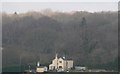
High Wood
The cottage in the foreground is Crossing Cottage http://www.geograph.org.uk/photo/1700818 at the Brambletye crossing http://www.geograph.org.uk/photo/1700814 on the Forest way.
Image: © N Chadwick
Taken: 6 Feb 2010
0.18 miles
8
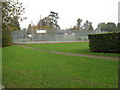
Tennis courts at John Pears Recreation Field
Donated by Mrs Pears in memory of her husband. The local Strawberry Fair was first held in the field in 1978 but no longer an annual event.
Image: © Dave Spicer
Taken: 24 Oct 2012
0.22 miles