IMAGES TAKEN NEAR TO
Ashdown Close, FOREST ROW, RH18 5DF
Introduction
This page details the photographs taken nearby to Ashdown Close, RH18 5DF by members of the Geograph project.
The Geograph project started in 2005 with the aim of publishing, organising and preserving representative images for every square kilometre of Great Britain, Ireland and the Isle of Man.

There are currently over 7.5m images from over14,400 individuals and you can help contribute to the project by visiting https://www.geograph.org.uk
Image Map
Images are licensed for reuse under creativecommons.org/licenses/by-sa/2.0
Notes
- Clicking on the map will re-center to the selected point.
- The higher the marker number, the further away the image location is from the centre of the postcode.
Image Listing (44 Images Found)
Images are licensed for reuse under creativecommons.org/licenses/by-sa/2.0
Image
Details
Distance
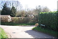
1
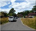
Ashdown Close, Forest Row
Post war estate built of Post Horn Lane.
Image: © Simon Carey
Taken: 4 Aug 2022
0.04 miles
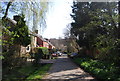
2
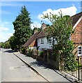
20-21, Post Horn Lane, Forest Row
Originally a single cottage marked on East Grinstead's 1841 tithe map that has since been extended.
Image: © Simon Carey
Taken: 4 Aug 2022
0.10 miles
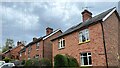
4
Primrose Lane, Forest Row
Cul de sac off Posthorn Lane that was developed from the first decade of the 20th century.
Image: © Simon Carey
Taken: 17 Apr 2021
0.12 miles

8
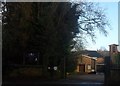
Our Lady of the Forest Catholic Church
Image: © Ed of the South
Taken: 13 Jan 2014
0.13 miles
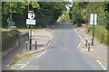
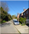
10
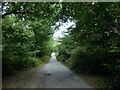
Shalesbrook Lane
Heading north to Forest Row through what may have a been the former Postern Gate.
Image: © Simon Carey
Taken: 4 Aug 2022
0.13 miles