IMAGES TAKEN NEAR TO
Stonedene Close, FOREST ROW, RH18 5DB
Introduction
This page details the photographs taken nearby to Stonedene Close, RH18 5DB by members of the Geograph project.
The Geograph project started in 2005 with the aim of publishing, organising and preserving representative images for every square kilometre of Great Britain, Ireland and the Isle of Man.

There are currently over 7.5m images from over14,400 individuals and you can help contribute to the project by visiting https://www.geograph.org.uk
Image Map
Images are licensed for reuse under creativecommons.org/licenses/by-sa/2.0
Notes
- Clicking on the map will re-center to the selected point.
- The higher the marker number, the further away the image location is from the centre of the postcode.
Image Listing (45 Images Found)
Images are licensed for reuse under creativecommons.org/licenses/by-sa/2.0
Image
Details
Distance
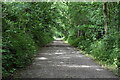

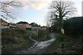
6
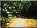
Forest Way, Forest Row
Forest Way at Forest Row, in East Sussex. Forest Way forms part of National Cycle Network route 21.
Image: © Malc McDonald
Taken: 14 Jul 2018
0.05 miles
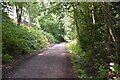
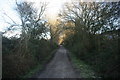
7
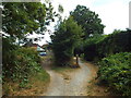
Forest Way at Forest Row
Forest Way passing behind houses in Forest Row, in East Sussex.
Forest Way forms part of National Cycle Network route 21.
Image: © Malc McDonald
Taken: 14 Jul 2018
0.05 miles