IMAGES TAKEN NEAR TO
Lewes Road, HAYWARDS HEATH, RH17 7SP
Introduction
This page details the photographs taken nearby to Lewes Road, RH17 7SP by members of the Geograph project.
The Geograph project started in 2005 with the aim of publishing, organising and preserving representative images for every square kilometre of Great Britain, Ireland and the Isle of Man.

There are currently over 7.5m images from over14,400 individuals and you can help contribute to the project by visiting https://www.geograph.org.uk
Image Map
Images are licensed for reuse under creativecommons.org/licenses/by-sa/2.0
Notes
- Clicking on the map will re-center to the selected point.
- The higher the marker number, the further away the image location is from the centre of the postcode.
Image Listing (27 Images Found)
Images are licensed for reuse under creativecommons.org/licenses/by-sa/2.0
Image
Details
Distance
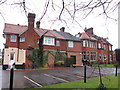
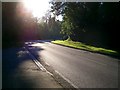
1
Lewes Road
The A272 on the outskirts of Haywards Heath. The area here was originally part of Wivelsfield parish until transferred to Haywards Heath in 1934.
Image: © Simon Carey
Taken: 30 Apr 2011
0.04 miles
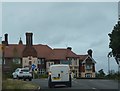
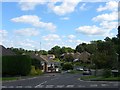
2
Lewes Road A272 Haywards Heath
This view Westwards shows part of the A272 on the East side of Haywards Heath after leaving the main built up area. Between the Princess Royal Hospital and the town boundary the A272 is lined with substantial detached houses set back from this busy road.
Image: © Geoff Dent
Taken: 26 Aug 2007
0.06 miles
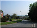
3
Beech Hill, Haywards Heath
A minor access route that runs in a loop on the eastern side of Northlands Avenue rejoining it to the north. Built as part of the Northlands estate in the 1970s on the former site of Northlands Wood which was transferred from the parish of Wivelsfield to Haywards Heath in 1934.
Image: © Simon Carey
Taken: 6 Sep 2015
0.08 miles
4
High Point, Haywards Heath
A small cul de sac off Northlands Avenue that was built in the 1970s as part of the Northlands estate that covers much of the former Northlands Wood. The wood was originally part of the parish of Wivelsfield until its transfer to Haywards Heath in 1934.
Image: © Simon Carey
Taken: 6 Sep 2015
0.13 miles
5
Northlands Avenue
Once part of Northlands Wood which as its name suggests formed the northern tip of the parish of Wivelsfield. Of the three sets of woods that once existed between what is now the B2112 in the centre of Haywards Heath and Lyoth Common this was the last to go being grubbed through the 1980s to build the current estate.
The area was transferred to Haywards Heath in 1934.
Image: © Simon Carey
Taken: 30 Apr 2011
0.14 miles
6
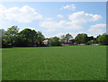
Little Lunces (2)
The name of the field according to Wivelsfield's 1843 tithe map that lies to the west of Image A new estate has been constructed at the end of the field.
Image: © Simon Carey
Taken: 20 Apr 2011
0.15 miles
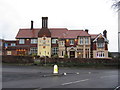
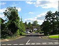
7
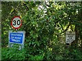
Old and New Road Signs
At the junction of Lewes Road, the A272, and Colwell Lane. The old pre-Worboys sign is on the right. This section of Haywards Heath was part of Wivelsfield parish until 1934.
Image: © Simon Carey
Taken: 30 Apr 2011
0.15 miles