IMAGES TAKEN NEAR TO
Monteswood Lane, HAYWARDS HEATH, RH17 7NS
Introduction
This page details the photographs taken nearby to Monteswood Lane, RH17 7NS by members of the Geograph project.
The Geograph project started in 2005 with the aim of publishing, organising and preserving representative images for every square kilometre of Great Britain, Ireland and the Isle of Man.

There are currently over 7.5m images from over14,400 individuals and you can help contribute to the project by visiting https://www.geograph.org.uk
Image Map
Images are licensed for reuse under creativecommons.org/licenses/by-sa/2.0
Notes
- Clicking on the map will re-center to the selected point.
- The higher the marker number, the further away the image location is from the centre of the postcode.
Image Listing (39 Images Found)
Images are licensed for reuse under creativecommons.org/licenses/by-sa/2.0
Image
Details
Distance
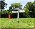
1
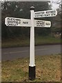
Direction Sign ? Signpost
Located on a grass triangle in the centre of the junction of Treemans Road and Monteswood Lane in Horsted Keynes parish. 3 arms and black iron cap finial.
Milestone Society National ID: SX_TQ3825A
Image: © R Evans
Taken: 4 Jan 2020
0.03 miles
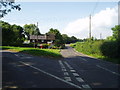
2
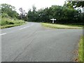
Junction of Treemans Road with Monteswood Lane
Image: © Dave Spicer
Taken: 14 Aug 2011
0.04 miles
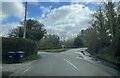
3
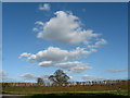
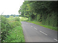
Lane, verge, hedge and trees
Beautiful Spring afternoon approaching Freshfield Crossways. The shape of the clouds seemed to complement the shape of the trees.
Image: © Nick Warner
Taken: 14 Mar 2009
0.07 miles
4
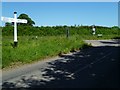
Signpost at junction of Treemans Road and Monteswood Lane
Treemans Road is on the left.
Image: © Shazz
Taken: 21 May 2011
0.07 miles
7
Freshfield Crossways
Crossways is a good description !
Image: © Nigel Freeman
Taken: 7 Jul 2005
0.10 miles
8
Freshfield Crossways
Approaching the crossroads from the west.
Image: © Chris Thomas-Atkin
Taken: 20 Mar 2021
0.11 miles
10
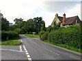
Freshfield Crossways
Little more than a few cottages based around a crossroads; Freshfield Lane in the foreground heads north to Danehill, Ketche's Lane to the left heads east to Sheffield Green, Sloop Lane to the south heads to the crossing over the River Ouse then onto Chailey (via Butterbox Lane) or Scaynes Hill (via Nash Lane), lastly, Monteswood Lane heads west, first to the junction with Image which heads north to Horsted Keynes, before continuing on to Lindfield via Walstead Common. The house on the right is Image
Image: © Simon Carey
Taken: 4 Aug 2015
0.12 miles