IMAGES TAKEN NEAR TO
Freshfield Lane, HAYWARDS HEATH, RH17 7HE
Introduction
This page details the photographs taken nearby to Freshfield Lane, RH17 7HE by members of the Geograph project.
The Geograph project started in 2005 with the aim of publishing, organising and preserving representative images for every square kilometre of Great Britain, Ireland and the Isle of Man.

There are currently over 7.5m images from over14,400 individuals and you can help contribute to the project by visiting https://www.geograph.org.uk
Image Map
Images are licensed for reuse under creativecommons.org/licenses/by-sa/2.0
Notes
- Clicking on the map will re-center to the selected point.
- The higher the marker number, the further away the image location is from the centre of the postcode.
Image Listing (136 Images Found)
Images are licensed for reuse under creativecommons.org/licenses/by-sa/2.0
Image
Details
Distance
1
Colourful display along side Freshfield Lane Danehill
Image: © Dave Spicer
Taken: 6 Jun 2009
0.01 miles
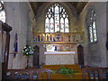
2
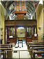
Interior view of All Saints church, Danehill
Image: © Nick Smith
Taken: 20 Apr 2010
0.02 miles
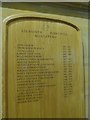
3
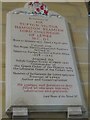
All Saints, Danehill: memorial (ix)
Also see https://en.wikipedia.org/wiki/Tufton_Beamish,_Baron_Chelwood
Image: © Basher Eyre
Taken: 3 Jun 2016
0.02 miles
4
Tower repair at All Saints church Danehill
Image: © Dave Spicer
Taken: 24 Oct 2010
0.02 miles
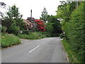
5
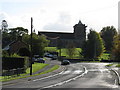
View along the A275 to All Saints church, Danehill
Image: © Nick Smith
Taken: 20 Apr 2010
0.03 miles

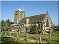
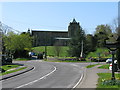
9
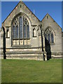
The eastern end of All Saints church, Danehill
Image: © Nick Smith
Taken: 20 Apr 2010
0.03 miles