IMAGES TAKEN NEAR TO
Birch Grove, HAYWARDS HEATH, RH17 7DQ
Introduction
This page details the photographs taken nearby to Birch Grove, RH17 7DQ by members of the Geograph project.
The Geograph project started in 2005 with the aim of publishing, organising and preserving representative images for every square kilometre of Great Britain, Ireland and the Isle of Man.

There are currently over 7.5m images from over14,400 individuals and you can help contribute to the project by visiting https://www.geograph.org.uk
Image Map
Images are licensed for reuse under creativecommons.org/licenses/by-sa/2.0
Notes
- Clicking on the map will re-center to the selected point.
- The higher the marker number, the further away the image location is from the centre of the postcode.
Image Listing (54 Images Found)
Images are licensed for reuse under creativecommons.org/licenses/by-sa/2.0
Image
Details
Distance
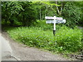
1
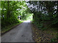
Unnamed lane signposted at both ends as "Narrow Road"
This is in West Sussex.
Image: © Shazz
Taken: 27 May 2017
0.02 miles
2
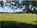
Poles Mead
The name of the field according to Maresfield's 1840 tithe map located to the south of Stumblewood Common.
Image: © Simon Carey
Taken: 20 Aug 2020
0.06 miles
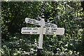
4
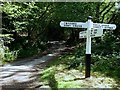
Top Bins, Oh Yeah, Alleluia
Someones been playing silly devils with one of the finger posts on this road sign at the junction of Birchgrove Lane and Twyford Lane. The other side still has the correct destinations: Sharpthorne, West Hoathly, Bluebell Railway.
Image: © Simon Carey
Taken: 20 Aug 2020
0.09 miles
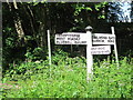
5
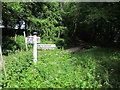
Signpost on Birchgrove Lane
See also http://www.geograph.org.uk/photo/3001086. This is in West Sussex.
Image: © Shazz
Taken: 27 May 2017
0.09 miles
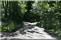
9
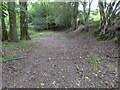
"White road" going north from Birchgrove Lane
This is mapped as a white road but is impassable for four wheeled motor vehicles. This is in West Sussex.
Image: © Shazz
Taken: 27 May 2017
0.10 miles
10
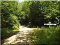
Road junction in Ashdown Forest
A junction of four country lanes in Ashdown Forest.
This junction lies on the county boundary of West and East Sussex, although the boundary is not marked.
Image: © Malc McDonald
Taken: 14 Jul 2018
0.10 miles