IMAGES TAKEN NEAR TO
Wyatts Lane, HAYWARDS HEATH, RH17 7AH
Introduction
This page details the photographs taken nearby to Wyatts Lane, RH17 7AH by members of the Geograph project.
The Geograph project started in 2005 with the aim of publishing, organising and preserving representative images for every square kilometre of Great Britain, Ireland and the Isle of Man.

There are currently over 7.5m images from over14,400 individuals and you can help contribute to the project by visiting https://www.geograph.org.uk
Image Map
Images are licensed for reuse under creativecommons.org/licenses/by-sa/2.0
Notes
- Clicking on the map will re-center to the selected point.
- The higher the marker number, the further away the image location is from the centre of the postcode.
Image Listing (156 Images Found)
Images are licensed for reuse under creativecommons.org/licenses/by-sa/2.0
Image
Details
Distance
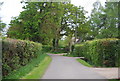
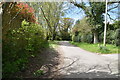
3
Wyatts Lane, Horsted Keynes
Heading southwards out of the village towards Wyatts. The lane is also a public bridleway. Orchard House is on the right.
Image: © Simon Carey
Taken: 20 Aug 2020
0.02 miles
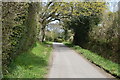
7
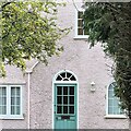
House on Wyatts Lane
Although the subject is only a few metres away from the camera, this is nevertheless a cross-grid shot. The house is in the square to the south.
Image: © Ian Hawfinch
Taken: 29 Mar 2022
0.04 miles
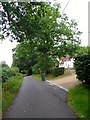
9
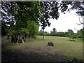
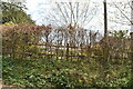
Burghurst Meadow
The name of the field according to Horsted Keynes' 1842 tithe map located to the east of Wyatts Lane.
Image: © Simon Carey
Taken: 20 Aug 2020
0.06 miles
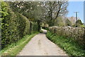
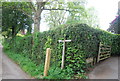
10
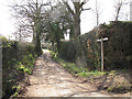
Wyatts Lane
This is the point at which the lane turns from a surfaced road into a bridleway, on the route of the Sussex Border Path.
Image: © Stephen Craven
Taken: 1 Apr 2013
0.06 miles