IMAGES TAKEN NEAR TO
High Street, HAYWARDS HEATH, RH17 6TD
Introduction
This page details the photographs taken nearby to High Street, RH17 6TD by members of the Geograph project.
The Geograph project started in 2005 with the aim of publishing, organising and preserving representative images for every square kilometre of Great Britain, Ireland and the Isle of Man.

There are currently over 7.5m images from over14,400 individuals and you can help contribute to the project by visiting https://www.geograph.org.uk
Image Map
Images are licensed for reuse under creativecommons.org/licenses/by-sa/2.0
Notes
- Clicking on the map will re-center to the selected point.
- The higher the marker number, the further away the image location is from the centre of the postcode.
Image Listing (144 Images Found)
Images are licensed for reuse under creativecommons.org/licenses/by-sa/2.0
Image
Details
Distance
1
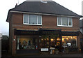
Ardingly Antiques
Ardingly High St opposite the Post Office
Image: © Robert Eva
Taken: 30 Dec 2016
0.01 miles
2
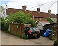
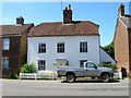
58-60, High Street, Ardingly
Number 58 is in the foreground and is currently a joiners whilst 60 is the cottage beyond. Both along with Image are set back from the main road.
Image: © Simon Carey
Taken: 6 Jun 2015
0.01 miles
3
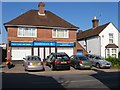
68, High Street, Ardingly
The former shop is now offices for Bluebird Care an agency dealing with home care.
Image: © Simon Carey
Taken: 11 Jun 2015
0.01 miles
4
Former shop, Ardingly
As with all villages in Sussex ending with a 'y', the village is pronounced Arding-lye.
Image: © nick macneill
Taken: 10 Aug 2012
0.01 miles
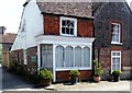
5
Ashley Cottages, High Street, Ardingly
A small terrace of cottages set back from the High Street that were built in the late 19th century.
Image: © Simon Carey
Taken: 6 Jun 2015
0.02 miles
6
20-22, High Street, Ardingly
Also known as Bough Cottage (number 20) and Bough House (22). The latter dates from the 17th century and at some point has been converted into a shop which has now returned to be just a dwelling. The former was added in the 18th or early 19th century.
Image: © Simon Carey
Taken: 11 Jun 2015
0.02 miles
7
70-74, High Street, Ardingly
Number 70 is the white building with 72 and 74 to its left, all seem to date from the late 19th century and are located on the eastern side of the street.
Image: © Simon Carey
Taken: 11 Jun 2015
0.02 miles
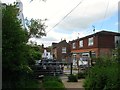
8
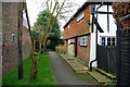
Cottages in alley, Ardingly
This alley runs behind the High Street, and houses are numbered in the same sequence.
Image: © Robin Webster
Taken: 1 Apr 2010
0.02 miles
9
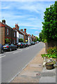
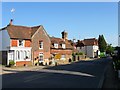
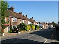
High Street
See Image for a more detailed history of this part of the village. The village post office is on the left hand side and is one of a number of shops here which include a bakers, Chinese takeaway, a deli and a hairdressers.
Image: © Simon Carey
Taken: 22 Jun 2008
0.02 miles
10
Holland House, High Street, Ardingly
The weatherboarded property dates from the mid 18th century and would have been erected when the settlement was known as Hapstead Green.
Image: © Simon Carey
Taken: 27 May 2015
0.02 miles