IMAGES TAKEN NEAR TO
Street Lane, HAYWARDS HEATH, RH17 6SZ
Introduction
This page details the photographs taken nearby to Street Lane, RH17 6SZ by members of the Geograph project.
The Geograph project started in 2005 with the aim of publishing, organising and preserving representative images for every square kilometre of Great Britain, Ireland and the Isle of Man.

There are currently over 7.5m images from over14,400 individuals and you can help contribute to the project by visiting https://www.geograph.org.uk
Image Map
Images are licensed for reuse under creativecommons.org/licenses/by-sa/2.0
Notes
- Clicking on the map will re-center to the selected point.
- The higher the marker number, the further away the image location is from the centre of the postcode.
Image Listing (136 Images Found)
Images are licensed for reuse under creativecommons.org/licenses/by-sa/2.0
Image
Details
Distance
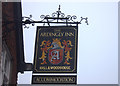
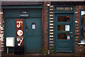
1
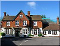
Ardingly Inn, Street Lane, Ardingly
Originally the Greyhound Inn and later hotel. Not sure when the name change occurred but the inn still provides abed and breakfast service.
Image: © Simon Carey
Taken: 6 Jun 2015
0.01 miles
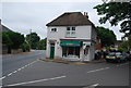
2
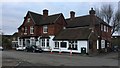
The Ardingly Inn
The Ardingly Inn viewed from the village car park.
Image: © Chris Thomas-Atkin
Taken: 5 Dec 2017
0.01 miles
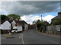
3
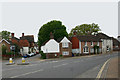
Ardingly
Taken from opposite the junction of College Road (left), Street Lane (centre) and High Street (right).
Image: © David Kemp
Taken: 21 May 2013
0.01 miles
7
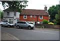
High Street, Ardingly
The B2028 viewed from the junction with College Road.
Image: © Simon Carey
Taken: 9 May 2015
0.02 miles
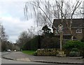
10

Junction of High St and Street Lane, Ardingly
Image: © Robert Eva
Taken: 30 Dec 2016
0.02 miles