IMAGES TAKEN NEAR TO
Balcombe, HAYWARDS HEATH, RH17 6RB
Introduction
This page details the photographs taken nearby to RH17 6RB by members of the Geograph project.
The Geograph project started in 2005 with the aim of publishing, organising and preserving representative images for every square kilometre of Great Britain, Ireland and the Isle of Man.

There are currently over 7.5m images from over14,400 individuals and you can help contribute to the project by visiting https://www.geograph.org.uk
Image Map
Images are licensed for reuse under creativecommons.org/licenses/by-sa/2.0
Notes
- Clicking on the map will re-center to the selected point.
- The higher the marker number, the further away the image location is from the centre of the postcode.
Image Listing (44 Images Found)
Images are licensed for reuse under creativecommons.org/licenses/by-sa/2.0
Image
Details
Distance
1
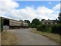
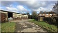
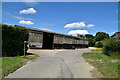
Newhouse Farm Cottages
Located to the east of Newhouse farm whose barns are on the left. They seem to date from the 19th century. There is a footpath junction in the foreground, straight on to Selsfield Common turn east for Selsfield Road, the B2028.
Image: © Simon Carey
Taken: 27 Jun 2015
0.01 miles
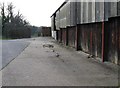
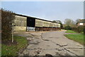
4
Newhouse Farm
Approaching Newhouse Farm with a footpath turning off right into the fields.
Image: © Chris Thomas-Atkin
Taken: 7 Jan 2018
0.03 miles
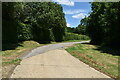
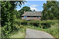
9
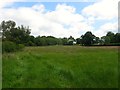
Stack Mead
The name of the field according to Ardingly's 1840 tithe map that is bounded by Image to the west, Image to the east and Image to the south.
Image: © Simon Carey
Taken: 27 Jun 2015
0.04 miles