IMAGES TAKEN NEAR TO
Haywards Heath Road, HAYWARDS HEATH, RH17 6QR
Introduction
This page details the photographs taken nearby to Haywards Heath Road, RH17 6QR by members of the Geograph project.
The Geograph project started in 2005 with the aim of publishing, organising and preserving representative images for every square kilometre of Great Britain, Ireland and the Isle of Man.

There are currently over 7.5m images from over14,400 individuals and you can help contribute to the project by visiting https://www.geograph.org.uk
Image Map
Images are licensed for reuse under creativecommons.org/licenses/by-sa/2.0
Notes
- Clicking on the map will re-center to the selected point.
- The higher the marker number, the further away the image location is from the centre of the postcode.
Image Listing (173 Images Found)
Images are licensed for reuse under creativecommons.org/licenses/by-sa/2.0
Image
Details
Distance
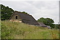
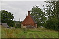
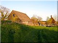
4
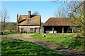
Ryelands Farm
The old barn is in quite good repair.
Image: © Robin Webster
Taken: 1 Apr 2010
0.01 miles
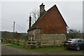
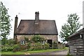
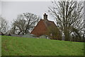
8
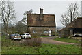
Ryelands Farm
The farmhouse on the right may date back as far as the 14th century
Image: © Simon Carey
Taken: 18 Apr 2015
0.02 miles